More showers expected in Philadelphia region Thursday, but relief is on the way


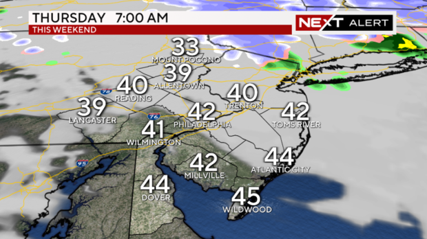
PHILADELPHIA (CBS) -- The winds have subsided but the flooding threat continues Thursday, with pockets of showers and sprinkles. The ground is supersaturated, so anything that does fall can likely continue to cause flooding issues. Morning lows will be in the 40s.
Thursday will start out dry with mixed skies, and there's a short moment of clearing this morning. Then, sadly, more clouds roll in.
Another area of low pressure moving into the northeast will provide us with afternoon and evening showers. Severe weather Thursday is NOT likely, although we cannot rule out some lightning and thunder with a few of the heaviest bands of rain. Skies should begin to clear late Thursday night into Friday.
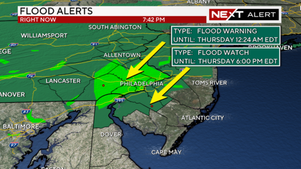
A Flood Watch is currently in effect for most of the Philly region until 6 p.m. on Thursday.
While Friday isn't completely dry, with a slight chance of a few showers (even some snow showers in the higher elevations north and west), we should see a bit of sun here and there. Highs will be in the 50s with breezy conditions throughout most of the day.
This all comes after several areas of low pressure moved near the Philadelphia region on Wednesday, creating an atmosphere for showers, storms and even severe weather to our south.
In Delaware, Sussex County was under a tornado warning earlier in the afternoon, due to a thunderstorm with rotation and very gusty winds. Thankfully, the storm weakened quickly before moving over the bay and toward New Jersey. As of Wednesday night, no tornadoes were confirmed.
Further north into New Jersey, pea to marble-sized hail was reported with a few of the gusty thunderstorms that blew through areas near Millville.
In Philadelphia, heavy rain and gusty winds were accompanied by lightning and thunder — just in time for the late-day commute.
Weekend weather in Philadelphia region leading up to eclipse
Even early Saturday may bring a shower or two across the region, as the area of low pressure stubbornly outlives its welcome in the northeast.
Finally by Sunday, we'll see a better shot at sunshine and dry conditions. We'll also see a turn in our temperatures, with many areas approaching the mid and upper 50s.
Next week, it will be partly cloudy and mild for Monday, which is the solar eclipse day! We'll keep mainly dry conditions around into the heart of next week, with highs approaching the 70s in a few spots by Tuesday!
Here's your 7-day forecast:
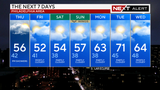
Thursday: High of 56, low of 42, PM showers
Friday: High of 52, low of 41, mostly cloudy
Saturday: High of 54, low of 38, partly cloudy
Sunday: High of 57, low of 38, partly cloudy
Monday: High of 63, low of 38, partly cloudy
Tuesday: High of 71, low of 45, partly cloudy
Wednesday: High of 64, low of 48, mostly cloudy
Get the latest weather info on the CBS News Philadelphia app.


