Frigid start to Wednesday in Philadelphia region, temps get warmer this weekend. Here's the forecast.
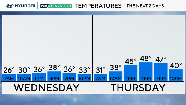
After a cold start to the morning with many areas below freezing, we'll see mixed skies and a run at mid to upper 40s across much of the Philadelphia region Wednesday. You'll need to start your day with a heavier jacket/coat as the wind chills will be in the 30s.
NEXT big weather change
Things are warming up starting Thursday, with temps jumping about 10 degrees and staying dry
A weak front Thursday night might bring a little rain (and maybe some snow north/west of I-95), but overall it keeps getting milder into Friday and Saturday, with a couple more chances of rain, mainly north and west.
By Sunday, it'll feel pretty warm — around 60-plus for a lot of the area before another front brings showers Sunday night. Then, it cools back down on Monday, and by Tuesday, it turns colder again with below-normal temps returning.
Spring officially begins on Friday at 10:46 a.m. in Philadelphia, and it will be pleasant in the mid-50s with partly sunny skies.
Here's your 7-day forecast:
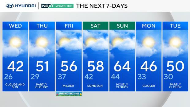
Wednesday: Clouds and sun. High 42, low 26.
Thursday: Partly cloudy. High 51, low 29.
Friday: Milder as spring begins. High 56, low 37.
Saturday: Some sun. High 58, low 42.
Sunday: Mostly cloudy. High 64, low 44.
Monday: Cooler. High 46, low 33.
Tuesday: Partly cloudy. High 50, low 30.