Cloudy skies, mild temperatures for Philadelphia Eagles-Commanders game Sunday

It's game day! The Philadelphia area will see a mixture of sun and clouds for the Eagles-Commanders NFC championship game.
Tailgating timeline at the Linc & Eagles game forecast
Temperatures on Sunday will be slightly above average for this time of year. Early morning tailgaters on Sunday saw mostly cloudy skies and a milder start to the day in the low to middle 30s. At kickoff, temperatures will reach a seasonable range in the low 40s, with a wind chill in the mid-30s.
Clouds will give way to little bits of sunshine late in the day, but don't worry the sun will come out tomorrow before clouds come back into the forecast Tuesday.
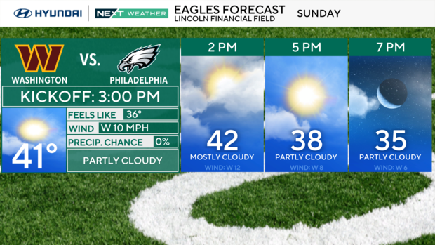
It'll be breezy at times on Sunday and at times, with wind gusts up to about 20 mph out of the west. Our NEXT Weather team doesn't anticipate this will affect the game much, but those inside the stadium will likely be zipping their jackets up a little bit higher when those gusts come.
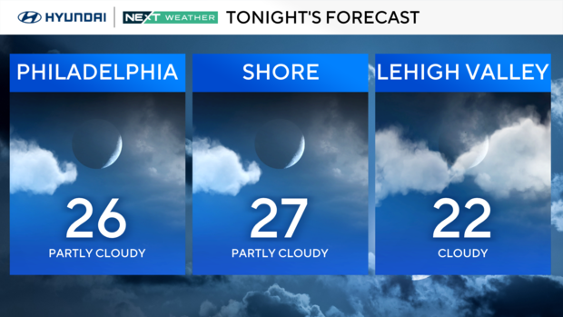
Sunday night will be mostly cloudy with temperatures in the 20s for any potential postgame celebrations in Philadelphia. No precipitation is expected, and temperatures will dip to the mid-20s. Any melted snow will refreeze, so be aware of the ice tomorrow morning.
Mild start to the week
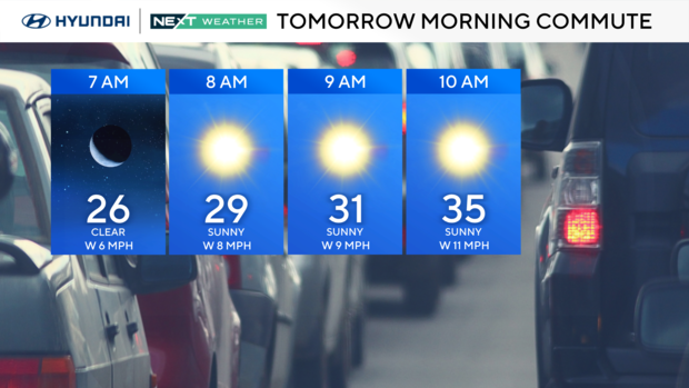
Looking ahead to Monday, the work week begins with sunny skies and temperatures in the 40s.
A series of weak clipper systems pass by to our north through Wednesday. These systems will be moisture-starved and bring periods of clouds but little or no chance of precipitation. A few snow showers are possible Tuesday morning and Wednesday night in the Lehigh Valley and Poconos.
Despite a milder, prevalent west-southwest wind, we will warm more slowly this week due to cooling from our remaining snowpack.
By Wednesday, it will almost feel balmy compared to the last week with temperatures in the upper 40s north and west of the city, with low 50s for Philly and mid-50s for areas south and east. Late Wednesday night, a stronger front arrives bringing the chance of a rain or snow shower pre-dawn on Thursday. Behind the front is another push of cold air, not as cold as last week but cold enough to drop us back to the 30s.
Clouds increase ahead of a storm system that will bring rain and a mix to the area Friday night and Saturday. Highs will be either side of 40 on both Saturday and Sunday. The rain showers may continue into Sunday morning and temperatures continue to rise into the low 50s for the first Sunday of February.
7-day NEXT Weather forecast:
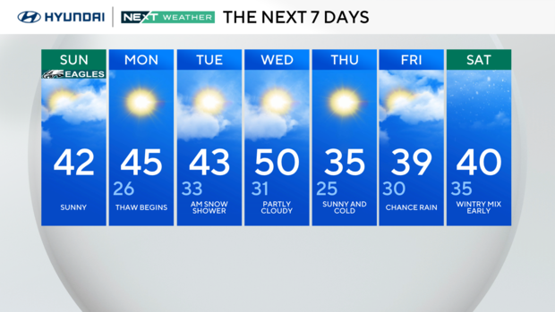
Monday: Thaw begins. High 45, Low 26.
Tuesday: AM Snow shower. High 43, Low 33.
Wednesday: Partly cloudy. High 50, Low 31.
Thursday: Sunny and cold. High 35, Low 25.
Friday: Chance of rain. High 39, Low 30.
Saturday: Wintry mix early. High 40, Low 35.


