Storms weaken Saturday evening in Philadelphia region. Here's the weather forecast.
A severe thunderstorm watch is in effect in southeastern Pennsylvania until 6 p.m. Saturday.
This severe thunderstorm watch includes Delaware, South Jersey, and Philadelphia, Delaware, Chester, and Montgomery counties in Pennsylvania.
Severe thunderstorm warnings are being issued as storms pop up.
Heat and humidity are building in our area — heat index values again may exceed 100 degrees. Scattered showers and thunderstorms develop during the afternoon and continue into the evening.
Not everyone sees a storm, but the strongest cells could bring damaging wind gusts, torrential rain, frequent lightning, hail and localized flash flooding.
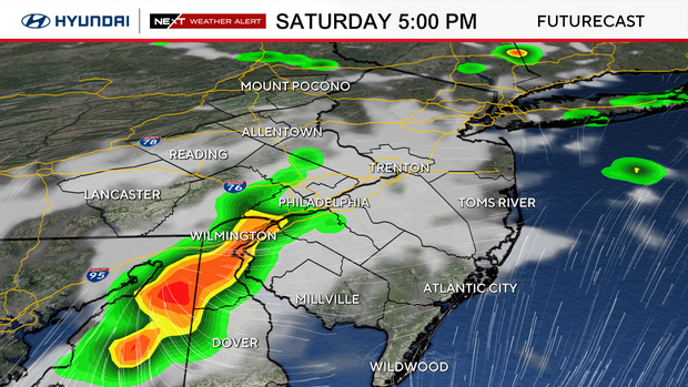
If you have outdoor plans Saturday afternoon or evening, have a backup plan and be ready to move inside quickly. Storms could disrupt outdoor events, sports, travel and other activities.
The combination of dangerous heat and storms makes Saturday the least favorable day for extended outdoor plans.
Earlier Saturday morning, our risk of severe weather was upgraded to a Level 2, or "slight" risk for parts of our area.
NEXT big weather changes
The good news: the storm threat drops significantly Sunday and Monday.
Sunday looks largely dry with plenty of sunshine and slightly lower humidity.
Monday looks similar, with sunshine, heat and a much lower chance for storms.
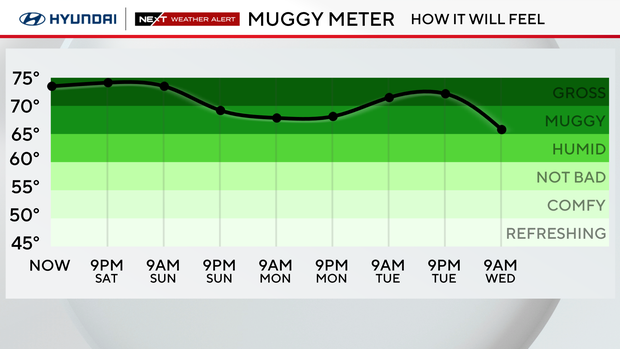
That makes Sunday and Monday better days for outdoor plans from a storm standpoint, but heat remains the bigger concern. Highs stay in the low to mid 90s, so plan around the hottest part of the afternoon, take breaks and stay hydrated.
The heat continues into Tuesday, with storm chances increasing ahead of a stronger front. That front should bring a better chance for storms Tuesday into Wednesday and finally break the prolonged heat. By the second half of next week, temperatures should return to the 80s.
Here's your 7-day forecast:
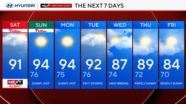
Saturday: NEXT Weather Alert for heat and thunderstorms. High 93, Low 76.
Sunday: Sunny, hot. High 94, Low 76.
Monday: Hot agains. High 94, Low 75.
Tuesday: Hot, storms. High 92, Low 76.
Wednesday: Heat wave ends. High 87, Low 74.
Thursday: Thunderstorm possible. High 89, Low 72.
Friday: Chance showers. High 84, Low 70.


