Philadelphia weather: Weekend storm starts out as wet snow, shifts to rain for most of region

This article is no longer being updated. Click here for the latest updates and how the storm will impact you in the Lehigh Valley, Philadelphia, South Jersey and Delaware.
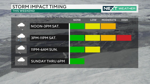
PHILADELPHIA (CBS) -- The winter storm that's headed our way Saturday has sped up and will arrive between 11 a.m. and 1 p.m. for much of the area. It will move quickly and begin clearing the area in the mid-to-late evening, around 10 p.m. and midnight.
This will likely begin as wet snow near Philadelphia but quickly change over to rain.
Any snow transitions to a wintry mix and eventually, all rain will happen within one to two hours for Philadelphia, lower Montgomery, lower Bucks, Delaware and Chester counties.
The rain will be heaviest between 4 p.m. and 8 p.m.
By late evening, a rain mix will cross upper Montgomery and upper Bucks counties and the Lehigh Valley.
Scattered snow and showers could wrap around the storm through Sunday morning with no snow accumulation expected. Skies will begin to clear late in the day.
Snow totals along I-95 will likely be measured in a few hundredths of an inch at most.
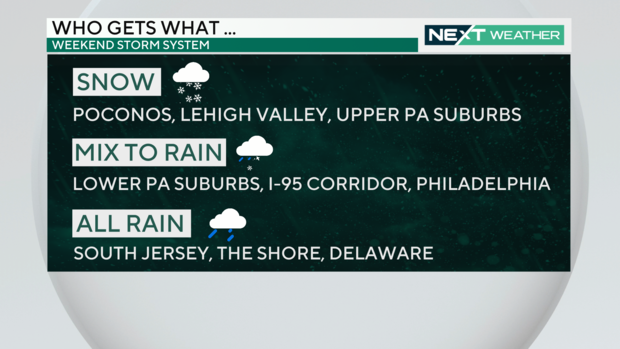
If you're in South Jersey and especially at the Jersey Shore, this storm is almost all rain for you.
The best chance to see anything over 2-3 inches would be north of I-78 into the Poconos, where it will stay snow for a longer duration and then possibly mix over later in the evening.
The National Weather Service has issued a Winter Storm Warning for the Poconos - Carbon and Monroe counties - from 1 p.m. Saturday to 6 p.m. Sunday.
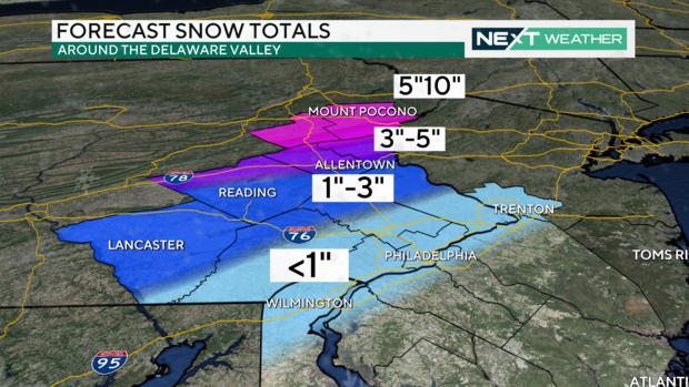
The Poconos themselves will likely remain all snow so this is where the totals will be impressive. At least 6 inches of snow are expected there.
The NWS has issued a Winter Weather Advisory for Lehigh Valley and Berks and upper Bucks counties.
We are then tracking another major storm for Tuesday bringing a rainy/windy event for our area, which will add to the flooding potential, especially in places that pick up the higher snow totals this weekend.
Here's your 7-day forecast:
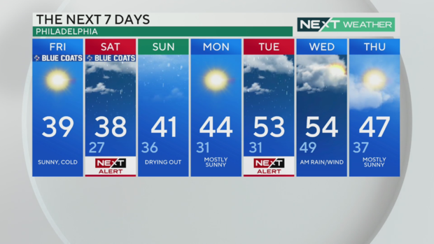
Friday: Sunny and cold. High 39
Saturday: NEXT Weather Alert Day for snow/rain mix across the region. High 38, Low 27
Sunday: Drying out. High 41, Low 36
Monday: Mostly sunny. High 44, Low 31
Tuesday: NEXT Weather Alert Day for a storm bringing heavy rain and wind. High 53, Low 31
Wednesday: AM rain and wind. High 54, Low 49
Thursday: Mostly sunny. High 47, Low 37


