Philadelphia, Pa. and NJ weather: How winter storm will impact you depending on where you live


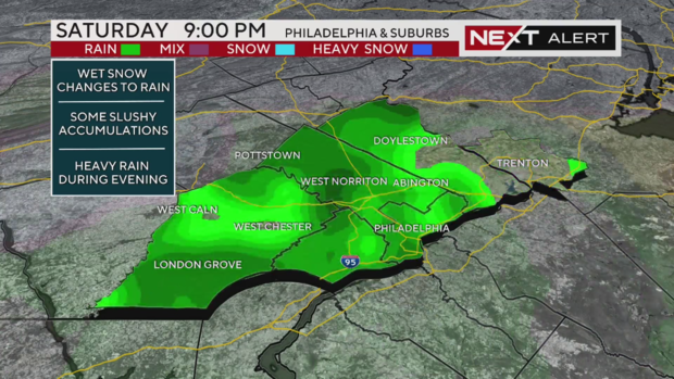
PHILADELPHIA (CBS) -- Moderate to heavy rain is falling across the Philadelphia area as of 8 p.m. Saturday. The changeover from snow to rain happened fairly quickly in the city, but snow is still falling north, into the Lehigh Valley and the Poconos.
There are winter storm warnings in effect for Carbon, Monroe, Lehigh and Northampton Counties.
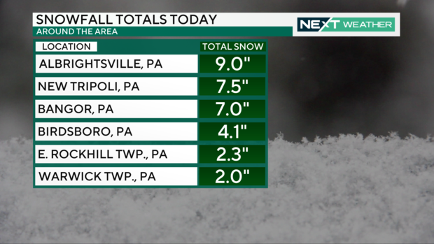
So far, 6 to 8 inches of fresh snow has fallen in the highest elevations of the Lehigh Valley.
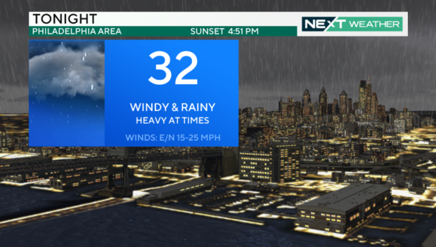
Elsewhere, temperatures are holding steady in the mid-upper 30s with the rain, so black ice and a freeze-over are not expected.
Still, drivers need to be cautious. Snow and slush have built up on some roads in the north, creating treacherous driving conditions. Rain is actively falling across South Jersey, the Jersey Shore and Delaware, so the roads there will be wet.
The storm has certainly looked different depending on whether you're in the Philadelphia suburbs, the Lehigh Valley or South Jersey and Delaware.
You've heard lots about this storm already, and the broad strokes remain the same as our NEXT Weather team has told you throughout this week:
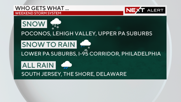
- Snow will continue across the Lehigh Valley and the Poconos tonight, although a changeover to rain is expected as it winds down closer to Sunday morning.
- Rain is the name of the game in the city of Philadelphia and the Jersey Shore.
- South Jersey and Delaware will see rain taper off shortly.
- A risk of refreezing overnight - slush or water could turn into ice in some areas across the Poconos and the higher elevations of the Lehigh Valley.
If you want to know what to expect as you plan your weekend, scroll down to the section for where you live, and we'll take you through it.
For the latest updates, be sure to download our CBS News Philadelphia app and stream us wherever we're streaming, including Pluto TV.
Our NEXT Weather meteorologists will be on top of all of your questions throughout the night as the storm winds down. They'll tell you who is getting what precipitation, what is falling where, when it's all happening and when it's out of here.
Our coverage of this storm is powered by our CBS NEXT Weather Network. Meteorologists from our fellow stations in Boston, New York and Baltimore are working together to track the storm's impacts. Stick with us and you'll see the storm work its way up through Baltimore, into our area and onward to New York and Boston.
We're working together - to keep you safe, and make sure you're always prepared, no matter where you are.
Philadelphia and suburban Pa. counties see snow at first before change over to rain
If you're in: Philadelphia, Delaware County, Chester County, Montgomery County or Bucks County, here's what you're going to see with this winter storm in southeastern Pennsylvania.
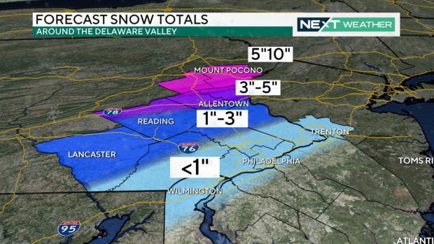
New forecast snow totals are slightly higher than they were Friday night. However, rain will wash much of that away by Saturday evening. The exceptions are the Lehigh Valley, the Poconos, Berks, upper Bucks, upper Montgomery and Upper Chester counties.
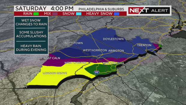
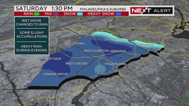
Snow was seen in the afternoon on Saturday, but then the changeover to rain began around 4 p.m.
A word to our readers, don't shovel along I-95, just wait for Mother Nature to wash it away.
The heaviest rain is during the evening and then shuts down by about midnight. Sunday morning we will see some wraparound snow flurries but they won't amount to much.
How much snow?
Wondering how much snow Philadelphia got? We didn't see much snow accumulate in this area, only a trace to maybe 2 inches. That snow washed away when the precipitation changed over to rain Saturday afternoon.
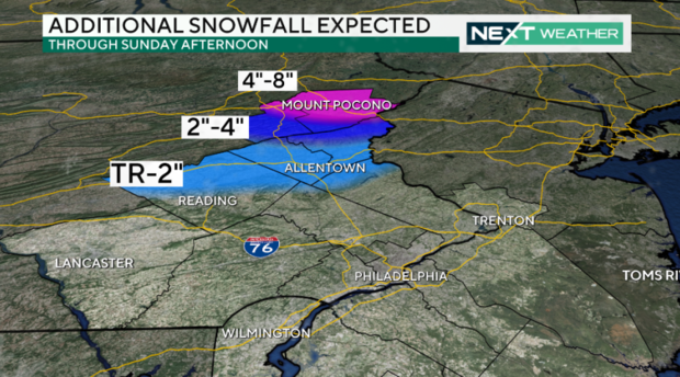
How much snow will fall in the Lehigh Valley, Poconos in Pennsylvania?
If you're in: Berks County, Lehigh County, Northampton County or the Poconos in Pennsylvania, here's what you need to know.
Snow was over Berks County and Reading at around 1 p.m. and then continued moving into the Lehigh Valley and Poconos.
By mid-afternoon, this entire region saw snow.
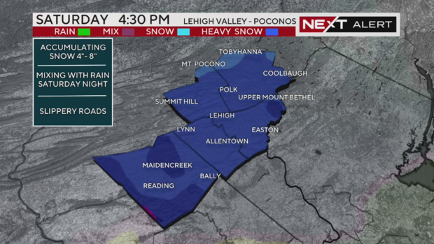
Snowfall continued across this section of Pennsylvania until around 7 p.m., when the rain started to move in for Berks County and southern Lehigh County.
If you're living there in Allentown or Easton, you're right on the transition line - it could keep snowing until as late as 10 or 11 p.m.
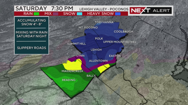
The farther north you go in this region, the more likely it's all snow.
How much snow?
The Poconos could see six to 12 inches of snow and the Lehigh Valley is looking at 4 to 6 inches. Snow in Berks County might accumulate but there will also be rain to wash some of it away.
Delaware sees almost all rain with this storm
The storm started as rain in the south Saturday morning. New Castle County, including Wilmington and Middletown, started with snow.
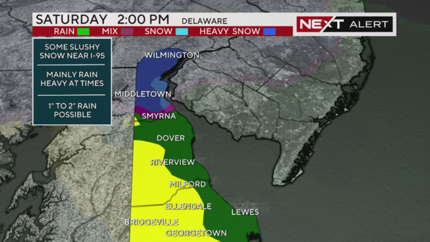
Heavy rain moved in Saturday night and was expected to clear out around 9 p.m. across the region.
The very tip of New Castle County and Wilmington could see some more flurries Sunday morning between 8-9 a.m.
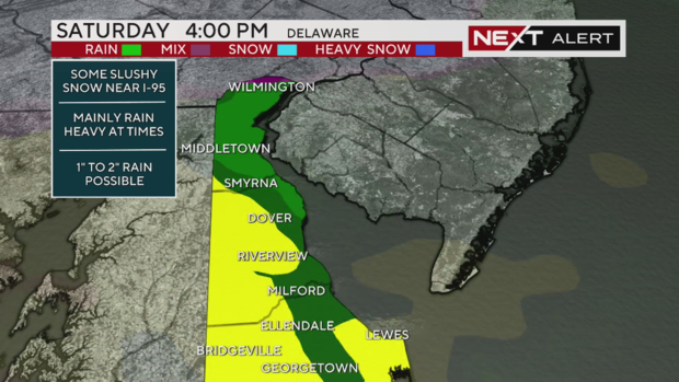
By the time the storm moves out, 1 to 2 inches of rain is possible across Delaware.
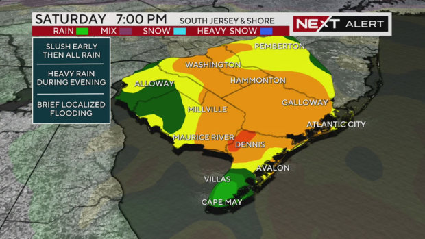
Not much snow in South Jersey - much more rain
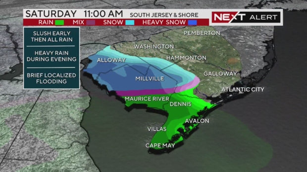
Areas closer to the I-95 corridor, including parts of Burlington, Camden and Gloucester counties, may have started with snow Saturday morning, but by 3 p.m. these areas all saw rain.
RELATED: Burlington County preparing for heavy rain
Some locations, including much of Atlantic County, saw heavy downpours.
The storm shuts down in South Jersey and the shore at around 10-11 p.m.
On the back side of the system, communities close to the I-95 corridor could see some light snow showers Sunday morning between 10 and 11 a.m.
How much snow? Wrong question. How much rain?
Any light coating of snow in South Jersey was washed away by rain. Rain totals could reach 1 to 2 inches in parts of South Jersey.


