Pa. weather: Snow less likely in Philadelphia as storm's track shifts, rain more likely
Latest forecast from Jan. 5, 2023, here: Projected snow totals for Pennsylvania
PHILADELPHIA (CBS) - The forecast of a coming weekend storm that threatened to bring the city's first accumulating snow is shifting, and it now looks like Philadelphia and the nearest suburbs in Pennsylvania will see mostly rain from this event Saturday.
Trends could still shift, but it's looking more likely that this is an all-rain or mostly rain event for South Jersey and Delaware, as well. Farther north of Philadelphia, snowfall is still possible but even the Lehigh Valley could still see rain.
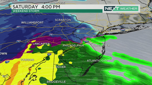
The latest models show some snow arriving in Philadelphia around midday Saturday, between noon and around 2 p.m. But after a couple of hours, the precipitation will likely shift to rain in the city and points south.
Saturday is a NEXT Weather Alert Day for this storm due to the potential for snow and the heavy rainfall that may cause flooding.
We're continuing to monitor this storm on TV and our CBS News Philadelphia stream, so check back often for the latest updates.
Who sees snow? How much snow is expected in Pennsylvania, New Jersey, Delaware?
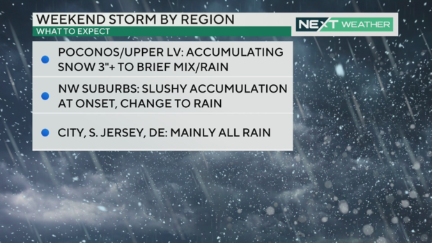
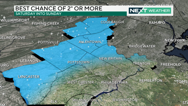
The Poconos and upper parts of the Lehigh Valley have the greatest chance of accumulating snow of 2 inches or more, and it will be a slushy accumulation at the outset. By the evening, even the Lehigh Valley could see some rain depending on the track of this storm.
The Pennsylvania suburbs northwest of Philadelphia will see a messy mix at first Saturday before a change to rain.
Philadelphia and South Jersey will mainly see rain though there could be some snow to start.
Into the evening, a plume of warm air will move north, making that change to rain. This rain will likely wash away any accumulating snow in Philly.
What has changed? Latest trends with the storm
The storm just came onto land and is only 48 hours out. Once it's on land, more weather balloons can get over it and analyze it, and the data is better the closer to a storm you get.
Warmer water in the Atlantic Ocean is disrupting our snow chances and warmer air is going to be pulled in.
The storm is also moving faster than previously expected, so it will get here earlier - possibly as soon as noon Saturday - and move out more quickly instead of lingering into Sunday.
Thursday morning: Cool and wet with a few flakes before clearing
Thursday morning we saw a band of snow showers in the Lehigh Valley and over the I-95 corridor in Delaware. The Shore and South Jersey saw some showers as well.
These bands of precipitation should clear out this morning and give way to a partly cloudy day with a high of 44 degrees.
Here's your 7-day forecast:
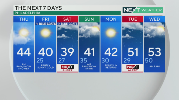
Thursday: AM rain/snow shower. High 44
Friday: Partly sunny, cold. High 40, Low 25
Saturday: NEXT Weather Alert Day for snow/rain chance; High 39, Low 27
Sunday: AM rain/snow showers possible. High 41, Low 35
Monday: Some sun returns. High 42, Low 30
Tuesday: NEXT Weather Alert for another storm. High 51, Low 29
Wednesday: AM rain. High 53, Low 50


