Subtropical Storm Josephine kicks up high surf while fantastic fall weather continues in Philadelphia

Philadelphia's fantastic stretch of fall weather continues Wednesday with little change.
Mostly sunny skies spread across the region as temperatures climb back into the mid-to-upper 60s. One thing you may notice through the day Wednesday will be a breeze picking up, especially closer to the coast from the newly named Subtropical Storm Josephine.
Wind gusts inland will range from 15-25 mph, but near the coast they could reach around 40 mph.
NEXT big weather changes
The region's next big change is the strengthening nor'easter — now named Josephine — passing offshore, although the greatest impacts should remain confined to the Jersey Shore and Delaware beaches.
Low pressure strengthening off the Carolina coast will gradually move northward, while high pressure remains anchored to our north. The tightening pressure gradient between these systems will produce a prolonged period of northeast winds, pushing water toward the beaches and into the back bays.
The duration of that onshore flow will be especially important, as several consecutive high-tide cycles could produce flooding.
Coastal flood advisories are in effect through Wednesday evening, with widespread minor flooding expected in vulnerable shore communities. The highest coastal flooding risk is expected around the Wednesday evening high tide.
Moderate flooding is possible on low-lying roads and in back bay communities, particularly where water doesn't fully drain between tides. Northeast wind gusts of up to 40 mph and seas reaching 7-12 feet could also produce dangerous marine conditions and additional beach erosion into Thursday.
For Philadelphia and our inland suburbs, the forecast remains much quieter. Josephine will begin to pull away Thursday, allowing winds and water levels to gradually subside, with highs rebounding to the upper 60s inland.
Another push of cooler air arrives Friday, bringing highs back into the lower 60s, followed by a chilly Friday night and Saturday morning with possible frost.
The weekend looks mainly sunny and dry, with temperatures gradually moderating from the lower to mid 60s Saturday to near 70 degrees Sunday.
The bottom line: beautiful fall weather continues inland, but several rounds of coastal flooding, strong winds and beach erosion concerns will affect the shore through midweek.
Here's your 7-day forecast:
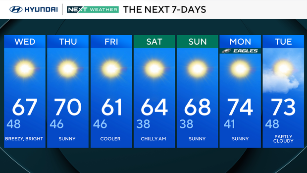
Wednesday: Breezy, bright. High 67, Low 48
Thursday: Sunny. High 70, Low 46
Friday: Cooler. High 61, Low 46
Saturday: Chilly a.m. High 64, Low 38
Sunday: Sunny. High 68, Low 38
Monday: Sunny. High 74, Low 41
Tuesday: Partly cloudy. High 73, Low 48
Get the latest weather info on the CBS News Philadelphia app.


