Freeze warning in parts of Philadelphia region after major drop in temperatures. Here's the weather forecast.

If you like clouds and drizzle, with chilly, breezy conditions in the 50s that feel like the 40s, then Saturday is your kind of weather day in the Philadelphia region. Conditions are perfect for indoor activities.
After early-morning showers, clouds will slowly erode from west to east, and sunshine will return later today.
Make sure your Halloween decorations are secure, because north winds will gust 30-35 mph this afternoon.
Saturday night, the coldest air yet this fall will settle in under clear skies. Temperatures will dip to the 30s.
NEXT big weather changes
Saturday night is our coldest night yet! A freeze warning is in effect until 9 a.m. Sunday for parts of the area and widespread frost is expected.
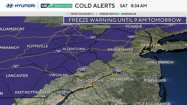
This alert is in effect in Upper Bucks, Upper Montgomery, Upper Chester, Berks, Lehigh and Northampton counties in our region.
Frost will be widespread elsewhere. Make sure you bring sensitive outdoor plants inside!
Sunday morning, you will be waking up to near-freezing temperatures in the 30s, quite a change from the 80s we experienced earlier this week.
Grab a warm coat for any outdoor plans in the morning. Skies will be sunny, and temperatures will climb to the upper 50s. A crisp fall day and perfect time to go leaf peeping. The Poconos and Lehigh Valley are nearing peak color.
It's also great football weather. Make sure to layer up and grab the sunglasses if you're headed to the Eagles game at 1 p.m. Temperatures will be in the mid-50s with northeast winds 5-10 mph under sunny skies.
Here's your 7-day forecast:
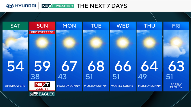
Saturday: Windy, colder. High 54, Low 52
Sunday: NEXT Weather Alert. High 59, Low 38
Monday: Mostly sunny. High 67, Low 43
Tuesday: Milder. High 68, Low 51
Wednesday: Seasonable. High 66, Low 51
Thursday: Pleasant. High 64, Low 49
Friday: Sunny and mild. High 63, Low 51
Get the latest weather info on the CBS News Philadelphia app.


