Summerlike warmth returns to Philadelphia before weekend cool-down. Here's the weather forecast.
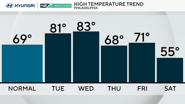
Get ready to break out the summer gear again as the Philadelphia region heads to the low 80s Tuesday. Humidity will stay low, and winds will be light, but the mostly sunny skies will make it feel a bit on the toasty side.
NEXT big weather changes
The NEXT big chance comes in two parts: a brief warm-up through Wednesday and a much stronger push of fall air heading into the weekend.
Wednesday could be the warmest day of the week, with temperatures approaching the mid-80s around the region. A cold front will slip south of the region Wednesday night, allowing cooler and drier air to move in Thursday.
Thursday looks beautiful, with sunshine, lower humidity and highs in the upper 60s. But then comes a much bigger change.
A strong upper-level trough will dig into the Northeast late this week, bringing a sharp drop in temperatures and some gusty winds.
An intensifying area of low pressure tracking through Canada will drag a strong cold front across the region Friday. Showers could develop as early as Thursday night, with the best chance for more widespread rain coming Friday. The exact timing is still uncertain, but this looks like a relatively progressive system rather than another prolonged rainfall event.
There could be some gusty winds accompanying the frontal passage, especially Friday afternoon and evening.
Behind that front is a serious shot of October chill. Temperatures may struggle to get out of the 50s both Saturday and Sunday, which would make this one of the coolest stretches of weather so far this season.
It will also be windy, with a tight pressure gradient developing between the departing storm system and high pressure building in from the west. That means even if there is plenty of sunshine over the weekend, it could feel considerably colder than the thermometer suggests.
Saturday, in particular, looks blustery, with highs only in the upper 50s and a gusty northwest wind. Sunday may be even cooler, with highs in the mid-50s.
Overnight lows could drop into the 30s in some of the colder suburbs by Sunday night, although it's still too early to determine whether frost will become a concern.
So after a wet weekend, there will be a few days of improving weather and a brief warm-up before the pattern changes dramatically again. The bottom line: the region is drying out and warming up through Wednesday, then trading the 80-degree weather for highs in the 50s by the weekend.
Here's your 7-day forecast:
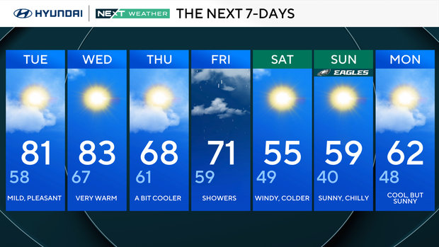
Tuesday: Mild, pleasant. High 81, Low 58
Wednesday: Very warm. High 83, Low 67
Thursday: A bit cooler. High 68, Low 61
Friday: Showers. High 71, Low 59
Saturday: Windy, cooler. High 55, Low 49
Sunday: Sunny, chilly. High 59, Low 40
Monday: Cool, but sunny. High 62, Low 48
Get the latest weather info on the CBS News Philadelphia app.