Philadelphia weather: Morning snow gives way to freezing rain and sleet, icy roads

PHILADELPHIA (CBS) -- Morning snow gave way to freezing rain on Tuesday after the Delaware Valley woke up to fresh snowfall.
As crews got to work and plowed the roads, leftover moisture presents a risk of freezing this afternoon and evening. Use caution as there could be icy spots out there.
Snow lovers are waking up to a fresh blanket of powder across the Delaware Valley Tuesday morning.
The snow is set to wrap up around noon, but a Winter Weather Advisory remains in effect until 1 p.m.
How much snow did we get so far?
As of 8 a.m., Philadelphia International Airport had recorded 3.3 inches of snow.
But snow totals across the region will go up once we get new numbers, and snow will continue to come down Tuesday morning into the early afternoon, though in some spots it'll look more like an icy mix.
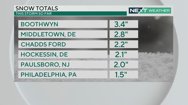
Areas to the north and west like the Lehigh Valley and Poconos could pick up another 1-3 inches before the storm moves out Tuesday afternoon, but across the region expect to see slick and icy roads during the morning commute.
By 3 p.m. in Philadelphia, only about another 0.2 inches is expected to fall.
RELATED: Dozens of schools reporting closures, delays
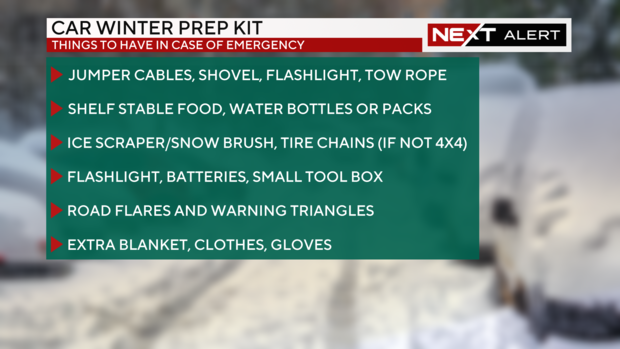
Car winter prep kit
With snow hitting the region this week, residents in the Philadelphia region should prepare their vehicles for driving in potentially dangerous conditions.
Below is a winter prep kit list:
- Jumper cables, shovel, flashlight, tow rope
- Shelf-stable food, water bottles or packs
- Ice scraper and snow brush
- Tire chains (if your car is not four-wheel drive)
- Flashlight, batteries, small tool box
- Road flares and warning triangles
- Extra blanket, clothes, gloves
More arctic air
You'll want to keep the heavy coats, hats and gloves close this week as another blast of arctic air with a wind chills settles in on Wednesday.
On Wednesday, at 6 a.m., the temperature will read 15 degrees but the wind will make it feel like the single digits. High temperatures that day won't make it out of the 20s, and it'll feel like the teens. And that's the warmest part of the day.
Wind chills will remain in the teens and single digits throughout the week, and it'll feel like below zero up in the Poconos.
Temperatures will likely stay below freezing through the weekend, possibly the longest stretch since 2018.
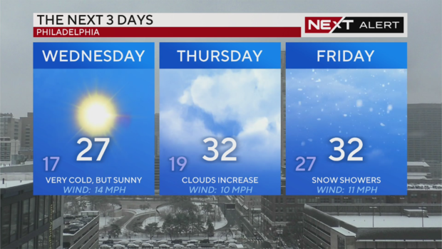
The coldest days of the week are Wednesday, high of 23 and low of 16, and Saturday, high of 27 and low of 18 degrees.
Air this cold can lead to frostbite, burst pipes, frozen standing water, car issues, and even fires from improper use of space heaters or stoves.
RELATED: Philadelphia International Airport reporting delays, cancellations Tuesday
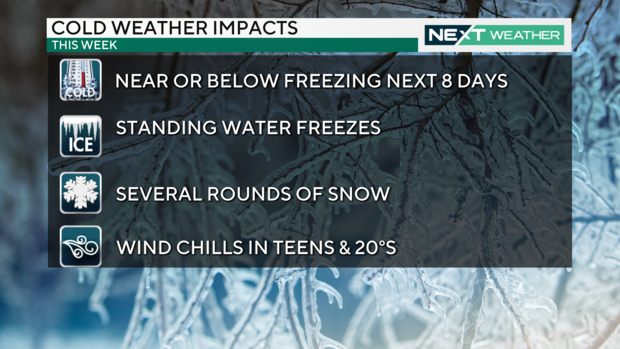
Another round of snow
And if all that wasn't enough, another bout of snow is expected at the end of the week.
This system could bring a few light snow showers thursday, but not much in terms of accumulation.
Then on Friday, we're tracking another 2-4 inches of snow in spots, but according to Meteorologist Kate Bilo, this system is "very complicated" and could end up just being snow showers, but there's also a possibility for more significant snow.
The storm track and timing could change before Friday night, so keep an eye on CBS Philadelphia for the latest forecast updates.


