Pennsylvania, New Jersey weather forecast: Bulk of rain to move out overnight Wednesday

PHILADELPHIA (CBS) -- The heaviest rain and gustiest winds moved out of the Philadelphia region overnight Wednesday after the storm pounded the Delaware Valley on Tuesday.
The Philly area will now be dealing with scattered showers and occasional wind gusts of up to 35 mph.
Since the storm began, many areas received well over an inch and a half of rain, with perhaps another 1 to 2 inches on top of that into Wednesday morning. The storm has forced some schools in the area to open late Wednesday.
RELATED: Residents in Pennsylvania, South Jersey bracing for major rainstorm
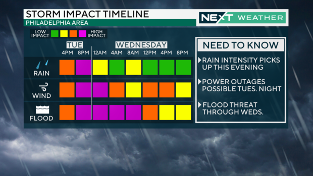
Here's what you need to know as the storm continues to impact the Delaware Valley.
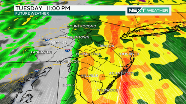
When will the storm end?
Light rain began to fall in the Philadelphia region around 9 a.m. and intensified in the afternoon.
The heaviest rain fell from 3 p.m. to 11 p.m., and by roughly midnight the bulk of the storm will be moving out of the area.
Following that, there will be some spotty showers overnight but flooding is likely until midway Wednesday.
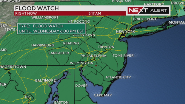
Watches and Warnings
A Flood Warning is in effect for Burlington, Camden, Gloucester and Mercer Counties in New Jersey and Bucks, Chester, Delaware, Montgomery and Philadelphia Counties in Pennsylvania until 3 a.m. on Wednesday.
A Flood Watch is also is in effect for the entire area until Wednesday night, and a High Wind Warning for the Jersey Shore and Cumberland County goes into effect tonight through Wednesday morning.
A Wind Advisory is also in effect for southeastern Pennsylvania, New Jersey and Delaware.
Let's talk about winds
The Philly region has already had gusts Tuesday evening of over 55 mph, with the potential for areas along the Jersey Shore to see gusts over 60 mph.
Eventually, as the front moves through, we'll see a gradual decrease in the winds, although it'll remain blustery and breezy throughout the day on Wednesday.
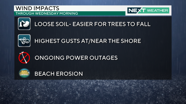
Power outages
Power outages will continue into the wee hours of the night, with over 180,000 customers without power across Pennsylvania, New Jersey and Delaware. That number has steadily climbed since 8 p.m. on Tuesday.
The soil and ground is so saturated that it really won't take much for trees and power lines to topple. If you lose power, remember to be careful with any candles you may light, making sure to never leave them unattended.
Freezer food can stay cold and frozen for up to 40 hours as long as the door is left shut.
Unusual amount of rain
This much rain falling on already saturated ground could lead to flash flooding.
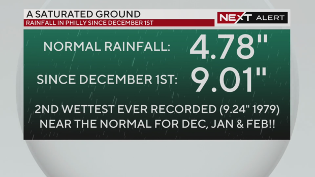
River, stream and creek flooding threats are highest on Wednesday. Normal rainfall totals between Dec. 1 and Jan. 9 amount to about 4.78 inches. Between December 2023 and Tuesday, we've seen more than 9 inches of rain, an amount normally recorded in December, January and February combined.
Those strong wind gusts could take down trees and power lines, leading to power outages. The highest winds will be down the shore, where high surf is likely to lead to some beach erosion.
Coastal flooding is also a threat with this system, where strong winds have the potential to push water onshore and into the back bays. High tide is around 6 p.m. Tuesday, and the morning high tide Wednesday is around 6:30 a.m.
New Jersey Gov. Phil Murphy declared a state of emergency due to the storm's potential impact.
The commute Tuesday night was a messy one with plenty of wet roads, low visibility, flooding, ponding and high winds.
The Wednesday morning commute is also likely to be a rough one. The bulk of the rain will have moved on, but head out with a backup plan in the event of flooded roads or downed trees.
Schuylkill River, streams, creeks to reach flood stage Wednesday
Rain moves out by Wednesday, but as water drains into creeks and streams they could reach flood stage. A flood stage is when the water level or has risen to areas that are not normally covered by water, which could cause an inconvenience, a threat to life or property.
Check out this tool from the National Water Prediction Service to see where in your area there could be flooding. Spots marked in red are "moderate" flooding, which is more severe than the minor flooding expected in other locations.
The National Oceanic and Atmospheric Administration warned residents near Rancocas Creek in New Jersey and Neshaminy Creek in Pennsylvania that the bodies of water could reach Wednesday.
"Definitely some roadway impacts, could be impacting some homes, in some cases it might be basement flooding or something like that," Robert Shedd of NOAA told CBS News Philadelphia.
River and stream levels are higher than normal because this has been a wet month.
The Schuylkill River at Boathouse Row is now forecast to get higher than 12 feet by Wednesday morning, which could lead to floods in Manayunk.
Here are some other rivers and creeks in the area expected to hit the major or moderate flood stage:
- Brandywine Creek in Downingtown: 11.3 feet around midnight, Major Flood Stage
- Delaware River at Burlington: 11.5 feet around 1 a.m., Major Flood Stage
- Christina River at Coochs Bridge in New Castle County: 13.2 feet around midnight, Major Flood Stage
- Schuylkill River at Norristown: 17.1 feet around 7 a.m., Moderate Flood Stage
- Neshaminy Creek near Langhorne: 13.1 feet, Moderate but near Major Flood Stage
Otherwise, conditions remain windy and cloudy on Wednesday.
Temps remain warmer throughout the week before next chance for rain on Saturday.
After that, expect colder, more seasonable temperatures.
Your 7-day forecast
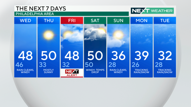
Wednesday: High of 48, low of 46, rain clears, windy
Thursday: High of 50, low of 33, mostly sunny
Friday: High of 48, low of 32, NEXT Weather Alert Day
Saturday: High of 50, low of 50, windy, temps drop
Sunday: High of 36, low of 28, rain clears, windy
Monday: High of 39, low of 26, tracking rain/snow
Tuesday: High of 32, low 28, tracking rain/snow
Get the latest weather info on the CBS News Philadelphia app.


