Friday will be dry, cool in Philadelphia as nor'easter moves closer. Here's the weather forecast.
Most of Friday is still pretty usable around Philadelphia. We'll spend much of the day under mostly cloudy skies with temperatures climbing into the lower 70s.
The breeze will be noticeable, but the air itself remains quite dry with dewpoints around 40. For daytime plans, leave the umbrella in the car but keep it nearby. Most of us stay dry through the afternoon, although a few showers rotating around the nor'easter could begin working inland from the Shore later today.
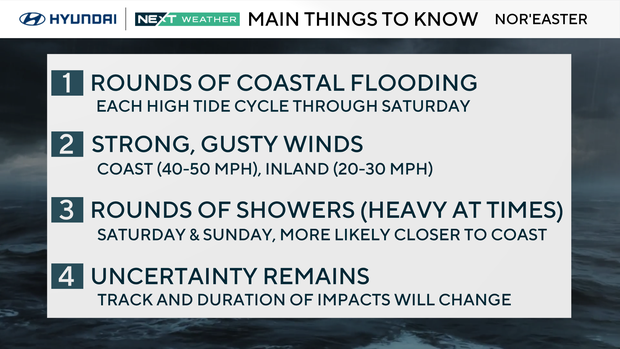
Winds become more of a factor heading into this evening and tonight. Expect a gusty north to northeast wind around Philadelphia, with considerably stronger winds toward the coast.
And the Shore remains a completely different story. This is not a beach or ocean day. Rough surf, dangerous rip currents, beach erosion and additional coastal flooding continue, and conditions deteriorate further as the storm strengthens and tracks north.
To see predicted high tides in your area, go to this page.
NEXT big weather changes
The forecast has shifted in an important way over the last 24 hours: the nor'easter is tracking closer to the coast, and weekend impacts now extend farther inland.
The storm strengthens as it moves north today and Saturday, then slows and begins to curl back toward the coast. That closer track allows bands of showers to rotate farther west into the Delaware Valley.
Saturday turns windy, cooler and wet. Bands of rain will work their way in by midday and continue to impact the area through Saturday night.
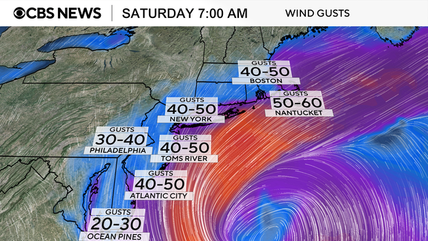
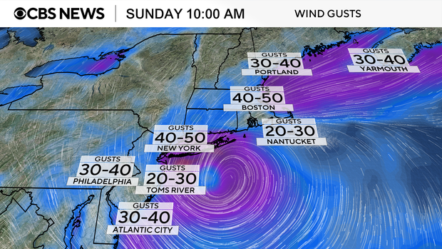
That wet, windy and chilly pattern continues through the day Sunday. As the storm loops back toward the coast, periods of rain become more likely around Philadelphia along with a persistent gusty north wind. It will be raw and cool with highs only in the lower to mid 60s, so Sunday outdoor plans are increasingly likely to be impacted.
The highest impact weather still stays at the Shore. Late today through Saturday looks like the peak, with strong winds, repeated coastal flooding, dangerous surf and significant beach erosion. Plan on wet conditions Saturday night.
Even as the storm weakens Sunday, lingering wind and the prolonged onshore flow will keep coastal concerns going.
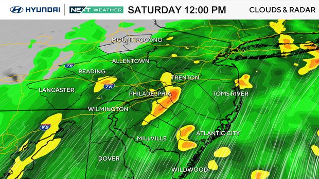
Sunday is the wildcard. There is still some potential for the nor'easter to loop or retrograde back toward the coast as it slows down, which could bring some showers with periods of heavy rain back into the area.
For now, that looks more like a shower chance than a major storm for Philadelphia, but Sunday impacts are now likely across the region, not just the shore.
That's why the NEXT Weather Alert remains in effect through Sunday. The alert is still primarily Shore-focused, but with the storm trending closer, Saturday afternoon and Sunday now bring a more meaningful rain and wind impact to the rest of the region as well.
The good news: the storm finally loosens its grip early next week. Monday trends drier, followed by a significant warmup with temperatures returning to the 70s Tuesday and potentially upper 70s by midweek.
Here's your 7-day forecast:
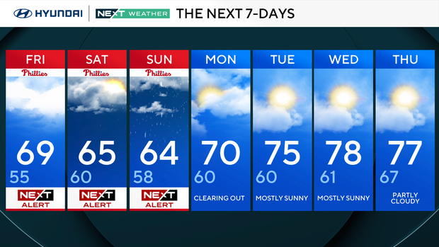
Friday: NEXT Weather Alert. High 69, Low 55
Saturday: NEXT Weather Alert. High 65, Low 60
Sunday: NEXT Weather Alert. High 64, Low 58
Monday: Clearing out. High 70, Low 60
Tuesday: Mostly sunny. High 75, Low 60
Wednesday: Mostly sunny. High 78, Low 61
Thursday: Partly cloudy. High 77, Low 67
Get the latest weather info on the CBS News Philadelphia app.


