Nor'easter brings coastal flooding, strong winds, rain to Jersey Shore, Philadelphia area


A coastal storm will continue to affect the Philadelphia region through Monday evening, bringing periods of rain, gusty winds and coastal flooding, especially along the New Jersey and Delaware shorelines. Conditions will slowly improve Monday night into Tuesday as the system weakens and drifts out to sea. High pressure will then build in mid-to-late week, setting up a stretch of dry and cooler weather.
As of Sunday evening, the primary low-pressure system off the Carolina coast is losing its influence on our weather as a secondary low develops off the Virginia coast. This evolution will keep the strongest winds and heaviest rain closer to the coast through Sunday while lowering rainfall totals slightly farther inland for the entire event.
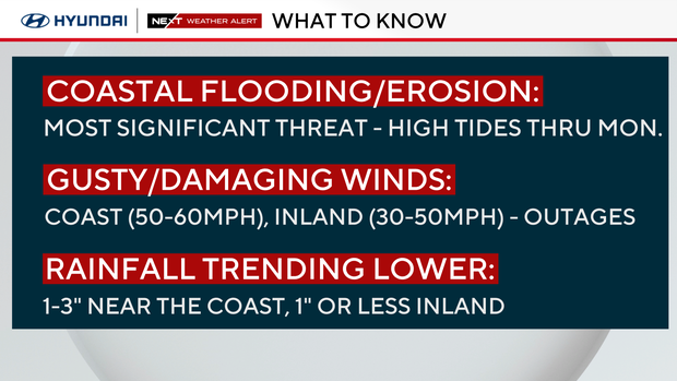
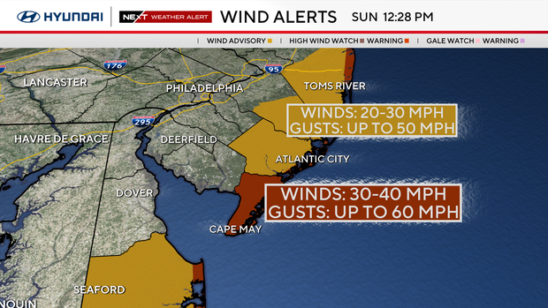
That said, wind and coastal flooding remain the main concerns. A high wind warning is in effect for Cape May County and the coastal strip, with gusts reaching 50–60 mph. Many locations along the shore have already recorded winds that high.
A wind advisory covers adjacent inland counties in southern New Jersey and Delaware, where gusts of 35–45 mph have already been observed. The combination of persistent onshore flow, high tides, and elevated surf could lead to moderate to major coastal flooding in the most vulnerable areas, along with beach erosion and rough marine conditions. Some tidal flooding was already realized during Sunday's midday high tide cycle.
A storm report from the National Weather Service revealed that approximately 2 feet of water was spotted covering 17th Avenue between New York and Delaware avenues in North Wildwood, New Jersey. Water levels were higher than the height of a sedan's bumper and nearly submerged a fire hydrant.
Over in Avalon, Ocean Drive was closed just south of Townsends Inlet due to tidal flooding and waves coming over the top of the road, according to another NWS storm report.
Upper Township administrator James Van Zlike said the dunes on the north end of Strathmere are "completely eroded," which has led to flooding along Sea Cliff and Seaview avenues. Those roads are barricaded until after Monday's high tide, he said in an email.
Rainfall totals
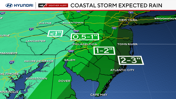
Rainfall totals are expected to range from 0.5 inch to 1 inch inland and 1 to 3+ inches along the coast. While the duration of the event limits the freshwater flooding threat, poor drainage flooding is still possible, and the rain may worsen tidal flooding in coastal zones.
The steadiest rain and strongest winds will occur from Sunday afternoon through Monday morning, as the secondary low-pressure system gains strength and maintains its influence on our region. By Tuesday, that system will start to move east, and only a few showers will be possible, especially along the Jersey Shore. Breezy conditions will remain before skies clear and high pressure brings cooler, quieter weather to close out the week.
By Tuesday, only a few lingering showers along the Jersey Shore and breezy conditions will remain before skies clear and high pressure brings cooler, quieter weather to close out the week.
Power outages reported in New Jersey due to storm impacts
With the gusty winds, some customers are also experiencing power outages, especially across South Jersey and into our shore points.
As of 6 p.m., there were more than 1,400 Atlantic City Electric customers without power, according to the online power outage map. Outage numbers will likely fluctuate as the storm moves through the region due to the strong wind gusts forecasted for Sunday and Monday. An Atlantic City Electric spokesperson said earlier Sunday that crews will work to restore power services to its customers as quickly and safely as possible.
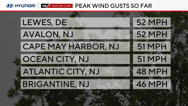
Some peak wind gusts so far on Sunday include 52 mph in Lewes, Delaware, and Avalon, New Jersey, as well as 51 mph in both Cape May Harbor and Ocean City, New Jersey.
Road closures, public transportation service updates
The storm has also led to a multitude of road closures and impacts on public transportation.
Absecon Police Department said officers were working with the New Jersey Department of Transportation to close U.S. Route 30 into Atlantic City due to flooding. South Shore Road is also currently closed, and South New Road was expected to close as well.
Drivers are advised to travel carefully in the area and seek alternate routes.
The North Jersey Coast Line rail service between Long Branch and Bay Head, as well as the Atlantic City Rail Line service between Atlantic City and Philadelphia 30th Street Station, was suspended at 1 p.m. due to heavy rain, winds and potential flooding from the nor'easter, NJ Transit posted on its website.
Here's your 7-day forecast:

Sunday: NEXT Weather Alert for rain, high winds, coastal flooding, beach erosion. High 64, Low 62.
Monday: NEXT Weather Alert for rain, high winds, coastal flooding, beach erosion. High 60. Low 57.
Tuesday: Showers leaving. High 70, Low 56.
Wednesday: Partly cloudy. High 69, Low of 55.
Thursday: Sunny. High 63, Low 47.
Friday: Sunny. High 64, Low 42.
Saturday: Partly cloudy. High 72, Low 45.