Heat and humidity return to Philadelphia area, pop-up storms possible mid-week. See the weather forecast.
After a relatively cool start to August, summer weather is returning to the Philadelphia area, which includes both heat and humidity.
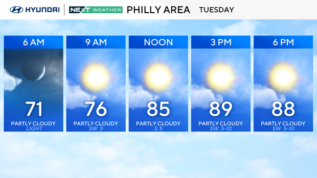
Tuesday will be hot but not extreme — upper 80s to low 90s for most, cooler near the coast. Humidity will be noticeable, but heat index values should stay just shy of advisory levels.
Temperatures will likely top out at 90 degrees, with humidity making it feel a bit warmer. We're also seeing patchy fog to start the morning, with pockets in Chester, Delaware, New Castle and Kent counties, and a bit at the Jersey Shore.
Code Orange air quality alerts in New Jersey, Pennsylvania
We also have air quality alerts in effect for Tuesday. Code Orange alerts have been issued in New Jersey and Pennsylvania due to ozone levels. The Department of Environmental Protection in each of these states says concentrations of ozone may reach levels Tuesday that will be unhealthy for sensitive groups. Ozone can build up when heavy, stagnant air holds in pollution.
Sensitive groups, including children, the elderly and people with respiratory conditions, should limit heavy outdoor activity during these conditions.
As far as heat and humidity, Wednesday looks about the same, and we could see a couple of pop-up storms in the afternoon, but many areas will get little to no rain. Currently, the region is under a general thunderstorm risk, with the most likely timeframe for any storms being the afternoon and evening; however, the severe weather risk right now remains fairly low.
By Thursday, a weak cold front slips in, bringing just a slight chance for a shower or storm. Highs will be near 90 degrees again, with sticky dew points early in the day before they start to drop from northwest to southeast.
Friday into the weekend, that front may stall or fall apart. We could get a touch less humidity, but it'll still feel summery with highs in the low 90s. Rain chances stay low, and there's no sign of any extreme heat.
The heat will likely stick around through the weekend into next week.
In the tropics, we are watching the newest named storm, Tropical Storm Erin, currently with sustained winds of 45 mph, heading west at 22 mph. Forecast models continue the westerly track toward the Caribbean and Gulf, but eventually have the storm shifting north toward the Bahamas. It bears watching closely as it is likely to become a major hurricane, and the path could potentially pass by the east coast of the U.S.
We'll be keeping an eye on this storm as it continues to develop.
As of now, Erin is roughly 3,000 miles away from the Mid-Atlantic seaboard. Storms that develop in this region, on average, take approximately 10 to 12 days after forming to reach our shores.

Here's your 7-day forecast:
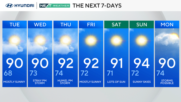
Tuesday: Mostly sunny. High 90, Low 68.
Wednesday: Stray p.m. storm. High 90, Low 73.
Thursday: Humid, p.m. storm. High 92, Low 74.
Friday: Mostly sunny. High 92, Low 72.
Saturday: Lots of sun. High 91, Low 71.
Sunday: Sunny skies. High 94, Low 72.
Monday: Storms possible. High 90, Low 74.