Why is it so cold right now in a warmer world?
WASHINGTON -- Anchorage, Alaska, was warmer Tuesday than Jacksonville, Florida. The weather in the U.S. is that upside down.
That's because the Arctic's deeply frigid weather escaped its regular atmospheric jail that traps the worst cold. It then meandered south to the central and eastern United States. And this has been happening more often in recent times, scientists say.
Why is it so cold right now?
Super cold air is normally locked up in the Arctic in the polar vortex, which is a gigantic circular weather pattern around the North Pole. A strong polar vortex keeps that cold air hemmed in.
"Then when it weakens, it causes like a dam to burst," and the cold air heads south, said Judah Cohen, a winter storm expert for Atmospheric Environmental Research, a commercial firm outside Boston.
"This is not record-breaking for Canada or Alaska or northern Siberia, it's just misplaced," said Cohen, who had forecast a colder than normal winter for much of the U.S.
Is this unusual?
Yes, but more for how long -- about 10 days -- the cold has lasted, than how cold it has been. On Tuesday, Boston tied its seven-day record for the most consecutive days at or below 20 degrees that was set exactly 100 years ago.
More than 1,600 daily records for cold were tied or broken in the last week of December, according to the National Oceanic and Atmospheric Administration (NOAA). For Greg Carbin of the National Weather Service's Weather Prediction Center, the most meaningful statistics are how last week's average temperature was the second coldest in more than a century of record-keeping for Minneapolis, Chicago, Detroit and Kansas City, third coldest in Pittsburgh and fifth coldest in New York City.
Global warming and cold weather
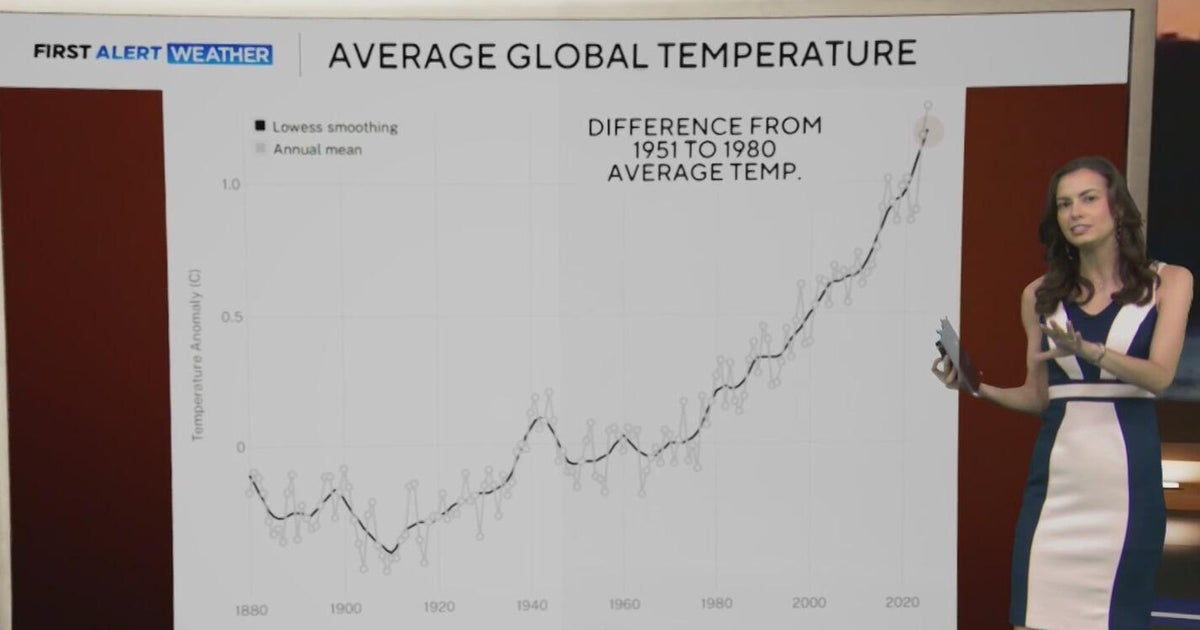
While the United States has been in the deep freeze, the rest of the globe has been toastier than normal. The globe as a whole was 0.9 degrees warmer than normal Tuesday and the Arctic was more than 6 degrees warmer than normal, according to the University of Maine Climate Change Institute's analysis.
"If you look at the temperature map for the climate as a whole right now, the entire rest of the planet is warmer than the historical average with the exception of the Eastern United States and Canada, and the last three years -- 2014, 2015 and 2016 -- have been consecutively the warmest years on record," atmospheric scientist and Columbia University professor Adam Sobel told CBS News last week.
What's next?
A brutal winter storm dumped snow, sleet and freezing rain from normally balmy Florida up the Southeast seaboard Wednesday, delivering a white coating that some cities hadn't seen in decades. Cars spun out of control on icy overpasses from Texas to Georgia. Forecasters warned that conditions could worsen, especially in the Northeast.
In the southern U.S., a wind chill advisory was in effect Wednesday from Orlando down to Boca Raton as a "bomb cyclone" storm was expected to swirl up the East Coast, said CBS News weather producer David Parkinson. He said when a storm system "loses 24 millibars of pressure, which is to say it gets that much stronger, in under 24 hours, you have what's called a 'weather bomb,' and so that's where you get the term 'bombogenesis' – that's where we talk about storms 'bombing out.'"
"Much sort of like a Sandy or a hurricane or something like that, it gets really strong really quickly, and when that happens you have these bursts of intense snow," he said.
If the storm moves just 25 miles in one direction or the other when it gets to the Northeast, that could be the difference between four and eight inches of snow, Parkinson said.
There is a blizzard concern along the coast – in Cape Ann, Mass., and along the state's southern coast. Winds are expected to be 40-70 mph.
"We're not going to have ridiculous snow totals that we've never seen before … But what we are gonna have is a lot of wind, a lot of low visibility and what I suspect will be a lot of traffic accidents," Parkinson said.
Forecasters warned of frost bite and hypothermia in Chicago, where wind chills of minus 35 degrees were predicted. According to CBS Chicago, many homeowners are already facing the consequences of frozen or broken pipes due to bone-chilling temperatures.
What makes the polar vortex move?
This is an area of hot debate and research among scientists and probably is a mix of human-caused climate change and natural variability, said Furtado. Climate change hasn't made the polar vortex more extreme, but it probably is making it move more, which makes the weather seem more extreme, he said.
A recent study by Potsdam Institute climate scientist Marlene Kretschmer found the polar vortex has weakened and meandered more often since 1990, but that study focused more on Europe. Ongoing research shows that there seems to be a similar connection for more frequent Arctic cold snaps like what the U.S. is now experiencing, Kretschmer said.
How can it be so cold with global warming?
Don't confuse weather -- which is a few days or weeks in one region -- with climate, which is over years and decades and global. Weather is like a person's mood, which changes frequently, while climate is like someone's personality, which is more long-term, Furtado said.
"A few cold days doesn't disprove climate change," Furtado said. "That's just silly. Just like a couple down days on the stock market doesn't mean the economy is going into the trash."