Hurricane Ian churns toward Florida, with "rapid strengthening" expected in coming days
The National Hurricane Center (NHC) upgraded Tropical Storm Ian to hurricane status early Monday morning, as authorities and residents in Florida kept a cautious eye on the storm rumbling northward through the Caribbean.
"Additional rapid strengthening is expected today," warned the NHC in a 5 a.m. Eastern advisory. The storm is expected to become a major hurricane as it approaches Florida's western coast by mid-week.
Governor Ron DeSantis declared a state of emergency for all of Florida over the weekend, expanding an initial order that covered two dozen counties. He urged residents to prepare for a storm that could lash large swaths of the state with heavy rains, high winds and rising seas.
Forecasters were still unsure exactly where Ian could make landfall, with current models plotting it toward Florida's west coast or panhandle regions, but CBS News meteorologist David Parkinson said early Monday that given the forecasting models, "a certain amount of storm surge destruction" in and around Tampa Bay appeared "nearly baked in at this point" when the storm does approach later in the week.
"We're going to keep monitoring the track of this storm but it really is important to stress the degree of uncertainty that still exists," DeSantis said at a news conference Sunday, cautioning that "even if you're not necessarily right in the eye of the path of the storm, there's going to be pretty broad impacts throughout the state.
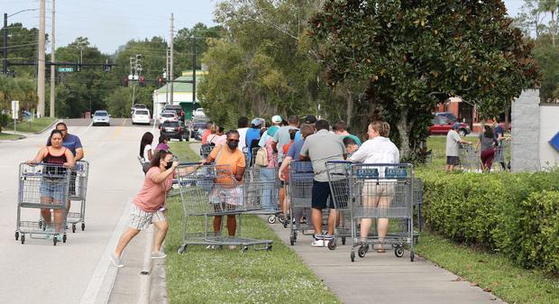
CBS News correspondent Omar Villafranca said residents along the Tampa Bay coast were preparing for the worst. Work was well underway over the weekend to pack sandbags as nervous anticipation led to long lines for gas and packed grocery stores, with some shelves quickly being cleared of basic necessities.
"I tried to get water, but it's no more," said one woman in Clearwater. "Not too much at this moment."
President Biden has also declared an emergency, authorizing the Department of Homeland Security and the Federal Emergency Management Agency (FEMA) to coordinate disaster relief and provide assistance to protect lives and property. The president postponed a scheduled September 27 trip to Florida due to the storm.
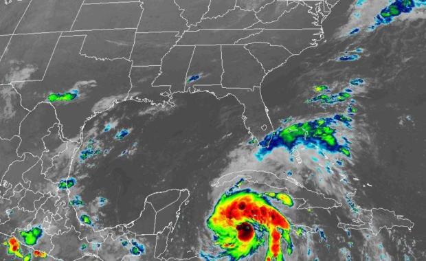
The National Hurricane Center (NHC) said Ian was expected to continue strengthening throughout the day Monday, becoming a hurricane later in the day and then a major hurricane by the time it nears Florida's west coast on Wednesday. The storm was located about 90 miles southwest of Grand Cayman as of 5 a.m. Eastern Monday morning, moving northwest at 14 mph with maximum sustained winds of 75 mph.
Before the expected impact in Florida, Ian was forecast to pass west of the Cayman Islands early Monday and then near western Cuba Monday night and early Tuesday, the NHC said. After that it will bring the possibility of flash flooding to the Florida peninsula and the Florida Keys, the agency added.
John Cangialosi, a senior hurricane specialist at the Miami-based center, said in an interview Sunday that it is not clear exactly where Ian will hit hardest. Floridians should begin preparations, including gathering supplies for potential power outages, he said.
"It's a hard thing to say stay tuned, but that's the right message right now," said Cangialosi. "But for those in Florida, it's still time to prepare. I'm not telling you to put up your shutters yet or do anything like that but it's still time to get your supplies."
In Pinellas Park, near Tampa, people were waiting in line at a Home Depot when it opened at 6 a.m., the Tampa Bay Times reported. Manager Wendy Macrini said the store had sold 600 cases of water by the early afternoon and ran out of generators.
People also were buying up plywood to put over their windows: "Better to have it and not need it than to need it and not have it," Matt Beaver, of Pinellas Park, told the Times.
The storm poses risk of "dangerous storm surge, heavy rainfall, flash flooding, strong winds, hazardous seas, and isolated tornadic activity for Florida's Peninsula and portions of the Florida Big Bend, North Florida, and Northeast Florida," DeSantis said in his executive order Saturday.
He encouraged all Floridians "to make their preparations."
Jamaica and the Cayman Islands could receive anywhere from 3 to 6 inches of rain, the NHC forecasted. Cuba could see 6 to 10 inches, while a wide area from the Florida Keys up into the central parts of the state could receive 2 to 4 inches.