EF-3 tornado strikes east Texas as severe weather slams Southeast
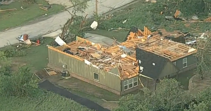
- An EF-3 tornado tore through Franklin, located in Roberston County in east Texas, destroying at least 20 structures.
- There were no fatalities in Franklin, two were injured and transported by ambulance to local hospital. Twelve others were injured but transported themselves, officials said.
- Two children are confirmed dead in Angelina County in south Texas, the sheriff's office said, after a tree fell on car.
- CBSN Jeff Berardelli said Saturday the threat for tornadoes was a four out of five, and kind of day we see in the U.S. only a handful of times each year.
A tornado struck Franklin, Texas, on Saturday, injuring at least a dozen people and causing damage to at least 20 structures in the east Texas town, officials said. A preliminary damage survey found the tornado reached peak intensity of EF-3 with 140 mph winds, the National Weather Service Fort Worth tweeted.
There were no fatalities. Mobile homes were damaged, cars were overturned and power lines were down, CBS Waco affiliate KWTX reports.
About 4,000 in Franklin have no power, officials said.
Robertson County Judge Charles Ellison said in a press conference that the south part of town had been hit the hardest. "It's totally destroyed," Ellison said.
Franklin Police Chief Terry Thibodeaux said it "looked like a bomb," CBS Houston affiliate KHOU reports.
"It's hard to describe," Thibodeaux said. "You've got houses turned over. You've got houses off foundations."
Severe weather hit Texas, Louisiana, Arkansas and Mississippi on Saturday. There were still tornado warnings in effect for parts of Mississippi and Alabama as of midnight Sunday.
Two children are confirmed dead after a tree fell on car during storms in Angelina County in south Texas, the sheriff's office said. And three people were injured in Ratcliff in Houston County (located 100 miles north of the city of Houston) when a tornado struck.
In Cherokee County, Texas, there were 16 injuries and several structures damaged, including the gym of Alto Elementary School.
CBSN contributing meteorologist Jeff Berardelli reported earlier reported the threat for tornadoes was a four on a scale of one to five -- the kind of day we see in the U.S. only a handful of times each year.
The bullseye for the biggest threat was east Texas, Louisiana, southern Arkansas and central Mississippi. Within this area, and extending outward a couple hundred miles in every direction, there is a heightened threat for strong, long-track tornadoes.
The parameters that meteorologists use to diagnose the severity of thunderstorms are calculated by how unstable the air is due to warmth and humidity, combined with the strength of winds. The numbers on Saturday, especially for something called the "significant tornado parameter," are about as high as they get in areas near Louisiana.
An upper-level storm system, powered by strong jet stream winds aloft, is combining forces with warm and humid air surging north out of the Gulf of Mexico. The combination will be enhanced by any heating due to breaks of sun between thunderstorms. As mentioned, the biggest threat is tornadoes, but large hail, frequent lightning, flash flooding and damaging straight-line wind gusts are all likely.
The worst of the storms will be found Saturday afternoon over east Texas moving into Louisiana, Arkansas and Mississippi. On Saturday night that threat moves into Tennessee and Alabama where storms will still be able to produce strong tornadoes.
Tornadoes are most dangerous at night because people often sleep through the threats. Also, you cannot see a tornado coming. Nighttime tornadoes are 2.5 times more likely to kill. Make sure your phone is on and ready to receive the latest warnings. Have a plan in place for the safety of your family.
On Sunday, the storm system will expand and move east. The thunderstorm threat area will be much broader from north Florida to Ohio and as far east as Pennsylvania, Virginia and North and South Carolina. Strong winds, large hail and a few tornadoes are possible. Overall the threat will be slightly less severe than Saturday's but still should be considered significant.
Traditionally "Tornado Alley" has been centered on the lower Plain States. And although that area still has the highest concentration of tornadoes, the zone has been shifting east the past couple of decades. The greatest increase in tornadoes recently is being found in the Deep South in an area now called "Dixie Alley" up to the Tennessee Valley.
In 2018, research confirmed this shift is due partly to a warming Gulf of Mexico and shifting climate patterns related to climate change and potentially natural climate cycles as well. This is important because the Deep South is more vulnerable to severe weather with higher population density, structures that often aren't sturdy and a greater likelihood that storms will hit during the night.


