SpaceX launches 3 satellites to monitor Canadian territory, impact of climate change
A SpaceX Falcon 9 rocket blasted off from a foggy California coast Wednesday, launching three Canadian radar satellites on a $900 million mission focused on maritime surveillance, resource management, disaster relief and the effects of climate change.
Using a C-band synthetic aperture radar system, the Radarsat Constellation Mission satellites will operate day and night, peering through cloud cover to monitor the vast northern reaches of the continent, Canada's long shoreline and maritime approaches.
"We have a very large country, and most of the population density is on the southern border," said Steve Iris, the RCM mission manager. "So we have a large part of the northern part of Canada that has a low-density population, and there's not a lot of infrastructure there to do monitoring. That's where there is the most impact from climate change, especially on the permafrost.
"So with the (Radarsat) mission, we'll be able to monitor that region every day, and to monitor subtle changes like ground deformation due to permafrost melting. We'll be able to do that (four times per day across the arctic), which is a big advantage compared to what we do now."
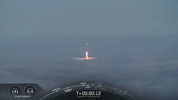
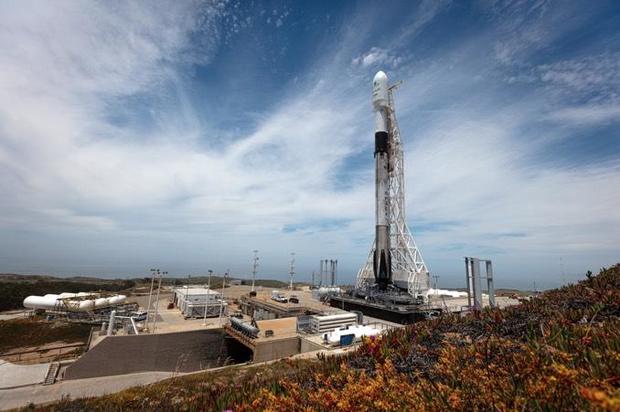
With morning fog shrouding space launch complex 4-East at Vandenberg Air Force Base, the Falcon 9 thundered to life at 7:17 a.m. PDT (10:17 EDT), its nine Merlin 1D engines throttling up to full power with a brilliant rush of flame. An instant later, the 229-foot-tall rocket was released from its firing stand to begin the climb to space.
Arcing away to the south over the Pacific Ocean, the slender booster quickly accelerated as it consumed its load of first stage propellants and lost weight, powering the rocket out of the dense lower atmosphere with 1.2 million pounds of thrust.
About two minutes and 17 seconds after liftoff, the previously flown first stage fell away, flipped around, restarted three engines to reverse course and headed back to Vandenberg. After another brief rocket firing to slow down for re-entry, the stage homed in on Landing Zone 4 at the Air Force base, restarting a single engine and settling to a pinpoint touchdown just a few hundred feet from the launch pad.
It was SpaceX's 41st successful booster recovery overall since December 2015. The company's record now stands at 26 landings on offshore drone ships, 13 at the Cape Canaveral Air Force Station in Florida and two at Vandenberg.
While the first stage was completing its return to Earth, the Falcon 9's single-engine second stage was completing the first of two firings to reach the intended orbit. The three RCM satellites were successfully released one at a time starting about 54 minutes after liftoff.
Tests and checkout are expected to take several months. Once complete, the satellites will begin routine observations under control of the Canadian Space Agency.
At a cost of about $1.2 billion Canadian dollars ($904 million U.S.), the RCM payload is one of the most expensive ever booked on a SpaceX Falcon 9.
Evenly spaced around the planet in a 373-mile-high polar orbit, the satellites will complete one trip around the planet every 96 minutes, beaming back 250,000 images per year and flying over the same point on the ground every four days. It took the earlier Radarsat 2 satellite 24 days to fly back over a given site.
"Why is this important? It's because we can use these images to measure changes in ground movement, for example, which can help us understand what's happening on the Earth better," said Magdalena Wierus, the Radarsat Constellation project management engineer.
"The RCM has the capacity to image any given location on 90 percent of the Earth's surface daily, but will be primarily imaging Canadian territory."
Canada has the longest coastline in the world, she said, and the second largest land mass. With a low-population density, space-based environmental monitoring is "a natural choice for monitoring our assets."
"In addition to our resource-based economy requiring monitoring of our forests, mining, energy, and agricultural industries, our northern latitudes that are sensitive to climate change gain from space-based radar systems that can observe the Earth day and night in any weather conditions," she said.
Along with the synthetic aperture radar instrument, the three satellites also carry Automatic Identification System -- AIS -- technology to record identification signals from ships at sea.
"Overlaid on top of the radar images this can help pinpoint ships that may be in trouble, or rogue ships that do not want to be found," Wierus said.
Over the next five days, each satellite's solar panels and radar antenna will unfold and lock into place. Tests and checkout will take another three to six months before routine operations begin.