Massive Sahara desert dust plume closing in on the United States
A massive plume of dust from the Sahara desert in northern Africa has been traversing the atmosphere, thousands of feet above the tropical Atlantic Ocean, and is now cloaking the Caribbean and closing in on the southeastern United States.
While summer dust plumes are a common occurrence, this appears to be one of the most extreme in recent memory. It's so large it has been nicknamed the Gorilla Dust Cloud.
"This is the most significant event in the past 50 years. Conditions are dangerous in many Caribbean islands," Pablo Méndez Lázaro, from the University of Puerto Rico's School of Public Health, told the Associated Press.
The latest NASA model projecting the path of the dust has it heading into the deep South from the Gulf of Mexico on Wednesday. The next round will hit Texas on Thursday through Saturday, and then hook back eastward over the Southeast and Tennessee Valley area.
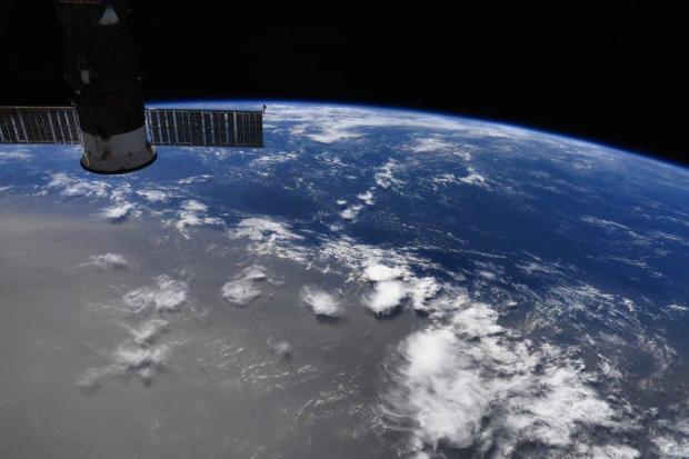
On satellite images from space, dust typically appears somewhat subtle and faint, but this plume can be seen as clear as day. The picture below was taken on Sunday from the International Space Station. "We flew over this Saharan dust plume today in the west central Atlantic. Amazing how large an area it covers!" astronaut Doug Hurley tweeted.
These plumes of Saharan dust, termed Saharan Air Layer (SAL) by meteorologists, are whipped up by strong wind storms crossing the Sahara desert. The dust enters the Atlantic Ocean near the Cape Verde islands, inside the Intertropical Convergence Zone where tropical systems often get their start.
NOAA's GOES satellite captured this series of animating images on Friday as the dust entered the deep tropical Atlantic from Africa.
The dust hitches a ride along the trade winds, a belt of east-to-west moving winds near the equator which become firmly established during summertime. The dust layer can extend from a few thousand feet above the surface to 20,000 feet up.
While the dust masses often stay generally intact during most of the trans-Atlantic journey, they typically become diffuse and diluted by the time they reach the Caribbean. However, so far, this particular dust layer is defying the odds.
Here are a series of before and after photos taken Sunday on Caribbean islands like Antigua, St. Barts, Puerto Rico and Trindad and Tabago:
When the dust is thick, it makes for very hazy yellow-brown skies. But when the dust is rather faint, the refraction and reflection of light can contribute to stunning sunrises and sunsets, which may help to at least partially explain Sunday's sunset in Miami.
Impact on health
The dust was so thick that the Barbados Meteorological Services issued a "Severe Dust Haze Warning" urging residents to take action due significantly reduced visibility and potential respiratory problems for people who experience difficulty breathing.
NASA satellites measure the intensity of dust clouds with a metric called Aerosol Optical Thickness (AOT). This metric indicates the degree to which aerosols prevent the transmission of light through the atmosphere: 0.01 indicates crystal clear skies, 0.4 corresponds with very hazy conditions, and a 4 means the pollution is so dense the sun can not be seen in the middle of the day.
On Tuesday, AOTs measured around 1.5 — very dense — in the thickest of the dust mass near the islands of Hispaniola and Jamaica, restricting visibilities to less than a mile in parts of the Caribbean and making for very unhealthy air quality as measured by the World Air Quality Index Project.
Research shows airborne dust can have adverse effects on health, with one of the most important being pulmonary disease. Inhalation of dust particles into the airways can initiate an inflammatory immune response. Dust is most unhealthy for people with pre-existing conditions like COPD, asthma and allergies, but dust as thick as the plume heading towards the U.S. may even be harmful to otherwise healthy people, if exposure lasts too long.
Another complication posed by this imminent dust cloud is its coincidence with COVID-19. A recent Harvard University study found that increased pollution, specifically particulate matter, like dust, can lead to higher hospital admissions and death rates from COVID-19. Health officials recommend wearing a mask for protection from inhaling the dust.
Cases of COVID-19 have been on the rise in Florida and Texas, which are in the path of the plume. As the dust overspreads the Southeast and then Texas, air quality index numbers are expected to be in the unhealthy range.
Dust clouds, hurricanes and climate
The dust is most commonly known to be a hurricane killer. Anyone who has lived in Hurricane Alley can tell you that these dry, dusty layers subdue the moisture needed to feed the hurricane engine. Typically when thick dust layers are around, tropical activity remains quiet, and that is what is expected over the next week.
Surprisingly, much of the soil, and nutrients in the soil, in places like South Florida and the Caribbean are composed of African dust which has settled over millions of years. In South Florida, in summer, almost half of airborne particles originate from Africa. Studies show that nutrients from African dust in subtropical and tropical soils may be critical to sustaining vegetation.
For the oceans it can be both a blessing and a curse. Scientists theorize that the nutrients transported from the Sahara desert have helped to build and nourish coral reefs in the Caribbean, Bahamas and Florida for millions of years. Without those minerals, they say, the area around the Bahamas is just too nutrient-poor to support the vibrant reefs that exist.
On the flip side, during years of severe dust storms, coral seems to suffer or even die off. One theory is that contaminants mixed in with the dust from agricultural practices in the Sahel region of Africa may be contributing. Also, too many minerals in the dust can cause hyper-fertilization, contributing to algae blooms that are harmful to coral.
In addition, the dust may also be contributing to warming our atmosphere. In a study published in this April, researchers found that scientific climate models currently underestimate the amount of coarse dust in our atmosphere by four times. That's because the models deposit the dust out of the atmosphere too quickly. The dust, they say, appears to have a net warming influence on our atmosphere.
But in the more immediate future, the biggest concern is how pervasive the dust layer will be in the tropical Atlantic this summer. With all signs pointing to a very active hurricane season, a more persistent dust layer could help defend against tropical activity. However, once the dust begins to settle, it appears there won't be much standing in the way of a busy hurricane season.