The 2023 Atlantic hurricane season begins June 1. Here's what experts say to expect.
The 2023 Atlantic hurricane season is expected to be "near normal" with at least 12 named storms, scientists from the National Oceanic and Atmospheric Administration predicted.
NOAA said ahead of the season's start it expects 12 to 17 named storms and five to nine hurricanes this year, with one to four major hurricanes.
"It's absolutely crucial that all Americans living in potential paths of these storms, even well inland of the coasts, follow NOAA's guidance for preparation and determine your risk, develop an evacuation plan, and assemble the disaster supplies that you may need," Deputy Commerce Secretary Don Graves said during a news conference last week.
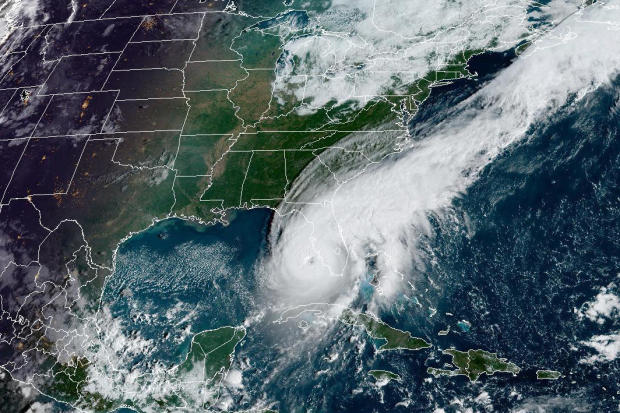
The Atlantic hurricane season runs from June 1 to Nov. 30. When a tropical depression reaches maximum sustained winds of at least 39 mph, it is considered a tropical storm and gets a name. A tropical storm becomes a hurricane when its sustained winds reach at least 74 mph, while major hurricanes — Category 3, 4 or 5 — are even more intense.
Climate change, driven by the burning of fossil fuels, has resulted in warming ocean temperatures and other atmospheric conditions that scientists say are making hurricanes more intense.
NOAA officials said that the effects of climate change could mean that storms yield more precipitation and slightly stronger winds than ever before, citing Hurricane Harvey, which dropped a record 5 feet of water on Texas in 2017.
The 2022 hurricane season produced 14 named storms, including eight hurricanes and two major hurricanes. According to NOAA, an average hurricane season consists of 14 named storms, seven hurricanes and three major hurricanes.
Even though the number of storms last year was about average, the intensity of those systems was extremely destructive. Just one storm, Hurricane Ian, caused 150 deaths and more than $112 billion in damage after it made landfall as a Category 4 in southwest Florida on Sept. 28. It was the costliest hurricane in Florida history and the third-costliest in U.S. history.
Researchers said that the emergence of an El Niño this summer could potentially make for a weaker hurricane season. El Niño and La Niña are naturally occurring climate patterns in the Pacific Ocean that can affect weather forecasts globally. The emerging El Niño means that waters off the West Coast will be warmer and storm activity in the Pacific more active, while Atlantic hurricane activity may be weakened. However, water temperatures in the Atlantic are currently above average, which could counteract an El Niño.
Officials touted upgrades to NOAA operations and forecasting that they hope will save lives this hurricane season. This year, NOAA will employ two new enhancements to better forecast the track and intensity of hurricanes and storm surge.
The National Weather Service provides resources for hurricane preparation and real-time updates about active weather systems at www.hurricanes.gov.


