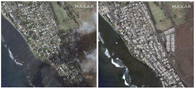
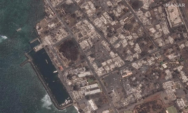
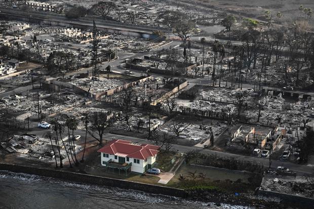
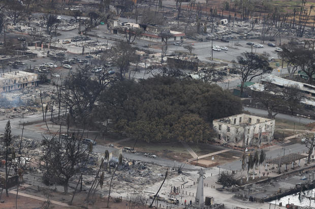
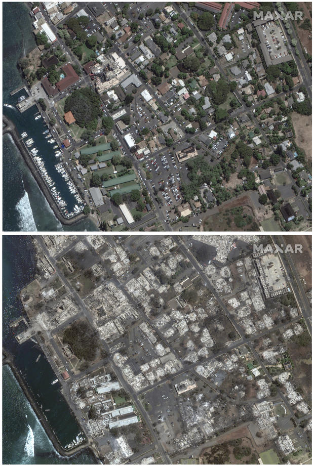
How much of Maui has burned in the wildfires? Aerial images show fire damage as containment efforts continue
The wildfires in Maui have burned thousands of acres since the blaze began earlier this month, and some of the fires were still partially contained as of Monday. The Lahaina fire – the most devastating of the blazes – burned an estimated 2,170 acres, the County of Maui said in a news release on Monday. That's about 3.4 square miles.
How much of Maui has burned?
Lahaina bore the brunt of the flames and the historic town was completely destroyed. With 2,170 acres burned, the Lahaina fire is about 90% contained, according to the release.
The wildfires began on Aug. 8 and since then, the Olinda fire in central Maui has burned an estimated 1,081 acres and the nearby Kula fire burned an estimated 202 acres. The Olinda fire was 85% contained and the Kula fire was 90% contained as of Aug. 27.
The Pulehu-Kihei fire was 100% contained as of Aug. 12. It is unclear how many acres burned in this fire, but on Aug. 15 officials estimated 3,200 had burned. Together, those estimates represent more than 10 square miles, of Maui's total area of 735 square miles.
The county said in a news release the still-burning fires are not posing active threats, even though containment of the fires hasn't changed in several days. "The fires are not advancing, but full containment can be more difficult to establish and determine in urban settings," the release reads. "[Maui Fire Department] continues to utilize infrared technology, water drops, and firefighters to locate and address hot spots in the ongoing effort to fully extinguish these fires."
Preliminary numbers released on Aug. 12 showed at least 2,200 buildings – about 86% of which are residential – were destroyed or damaged in the Lahaina fire, according to the University of Hawaii's Pacific Disaster Center.
The cost to rebuild was estimated to be $5.52 billion.
The fires also led to an unsafe water advisory for Lahaina and Upper Kula, which remains in effect, according to the news release. Residents are being asked to use only bottled water or potable water, which they can pick up at several centers in both of these areas.
About 1,800 Hawaii Electric customers in Lahaina are without power still, as are nearly 50 customers in Kula. The electric company is working to restore power to essential buildings like grocery stores and pharmacies and then they will look at individual businesses and private properties, according to news release.
On Facebook, the county warned residents about hazardous materials like asbestos, lead, ash, pesticides and other materials that may be present in the areas where structures burned. There may also be broken pipes and glass, exposed nails and other hazards such as propane tanks, which could be dangerous.
County officials urged those who can return to their properties to do so wearing personal protective equipment and to avoid all burn areas unless cleared by authorities.
Maui wildfires death toll
As of Aug. 27, 115 people were confirmed dead.
How many people are still missing in Maui?
The number of people missing on Maui was still unclear nearly three weeks after the fires broke out. Maui County Mayor Richard Bissen said Aug. 21 that 850 people were still listed as missing, citing data compiled by the FBI and local authorities. Later that week, an FBI official said the number of people "reported unaccounted for" is between 1,000 and 1,100. Maui County officials on Aug. 24 released the names of 388 people who were unaccounted for. Within a day of its release, more than 100 of those on the list or their relatives came forward to say that were safe, the FBI said.
More than 1,900 people are estimated to seeking shelter at one of the six Maui hotels being used shelters in coordination with the American Red Cross, according to the county's release.
Aerial images of Maui fire damage