Flooding and snow hit the West while parts of the South could see record-breaking warm temperatures on Christmas
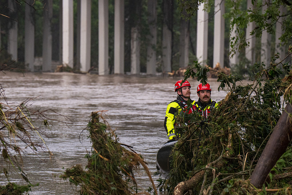
Residents along the West Coast can expect to see flash flooding throughout the holiday weekend, while snow will pile up in the mountains. The National Weather Service warns it'll be a "wet, wintry, windy, and a White Christmas for some in the West with hazardous travel conditions in mountainous terrain."
Storms have already washed out or damaged parts of some mountain roadways in Southern California.
The National Weather Service has issued a flood advisory until 12:30 a.m. tonight, local time, for western Los Angeles County, with urban and small stream flooding possible, as well as a flood advisory throughout parts of Arizona until Friday afternoon.
Over 6 inches of rain was reported in San Luis Obispo County, with more rain on the way through Christmas Day.
Residents in impacted areas are encouraged to watch out for standing water and flooded roadways and to never drive through them.
"The heavy traffic combined with the rainy conditions is causing very low visibilities on Valley freeways and highways today," the National Weather Service in Phoenix said on Twitter. "Your brakes also don't work nearly as good in the rain and on wet roadways. Please slow down and remember to drive safely in the rain."
Storms could even bring a rare chance of snow to Seattle and Portland.
Portions of northwest California, the Rocky Mountain National Park, Washington state, the mountains of Summit County, among other areas, are under winter storm warnings and hazardous weather outlooks through the weekend. Cooler than normal conditions are expected for Christmas Eve and Christmas Day.
Heavy snow is expected in higher elevations, with total accumulations for certain areas potentially reaching up to 22 inches. More than a foot of snow is expected in the Sierra Cascades and most of the Rockies' higher elevations on Christmas Eve, with even more heavy mountain snow expected by Christmas Day. On Christmas night, parts of the Sierra Nevada, Cascades and Salmon Mountains could measure more than four feet of snow.
The National Weather Service warns that travel during this time could be hazardous and "even impassable at times, in the hardest hit locations with towering snow drifts and whiteout conditions."
Residents are being urged to delay all travel, and to use extreme caution if they must leave home. Travelers are encouraged to keep a winter storm kit in vehicles in case of an emergency and to prepare for long delays. Those who stay home are advised to have a backup plan in the instance of power outages.
"These may be some of the coldest temperatures the region has experienced in at least the past 10 years," the National Weather Service's Inland Northwest Weather Blog said Thursday. "If you haven't already, now is the time to prepare."
Meanwhile, areas throughout much of the central and southern U.S. are getting an unusually warm holiday weekend, with temperatures that could break records.
"Those dreaming of a White Christmas throughout much of the South and East Central U.S. have to settle for spring-like temperatures this Christmas," the National Weather Service said Friday.
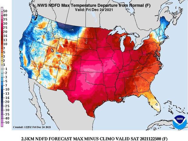
States from the middle Mississippi Valley to West Texas could see their warmest Christmas Eve and Christmas Day ever recorded, with high temperatures of 70 to 80 degrees Fahrenheit during the day, the weather agency predicts. That would be more than 30 degrees above average. Temperatures from the Ohio Valley to the Southern Plains are forecast to be 25 to 35 degrees above normal.