NEXT Weather: Storm with variety of precipitation moving in, with whiteout conditions Friday
MINNEAPOLIS – Frigid air, freezing rain and snow are all NEXT Weather factors for Minnesota's second week of spring.
The National Weather Service has a Winter Weather Advisory in effect from Thursday night through Friday north of the Twin Cities due to the possibility of freezing rain and accumulating snow.
The Dakotas through the southern half of Minnesota and western Wisconsin are under a Winter Storm Watch.
Friday will be a NEXT Weather Alert day due to rainfall by day that will flip to snow and accumulate into the night.
Flakes will change to rain showers, with a chance of thunderstorms in extreme southern Minnesota. The evening commute will be OK, but the roads will be wet, and there may be some slushy accumulation north of the metro.
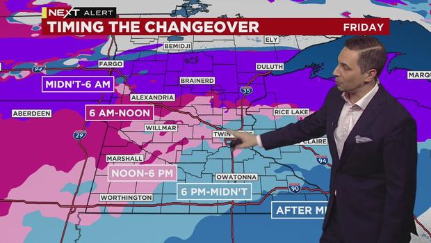
There will be a lull in the action Friday morning before the moisture increases. The wind will be a major player all day, with gusts as strong as 50 mph at times.
Cold air will wrap along the back side of the system, which means wet, heavy, accumulating snow. The biggest concern will be Friday night, where there could be near whiteout conditions in southwestern Minnesota. The storm will clear out early Saturday.
Snow total models are all over the place as of late Wednesday night, but it appears that 3-6 inches of accumulation is the best bet for this storm. But keep in mind that most of it will melt on contact.
This weekend will be quiet, with a chance of the metro hitting 50 degrees for the first time since late November.