NEXT Weather: Active week starts with snow showers Monday


MINNEAPOLIS — It's going to be an active weather week in Minnesota, starting with a system moving through Monday that should bring multiple inches of snow to parts of the state.
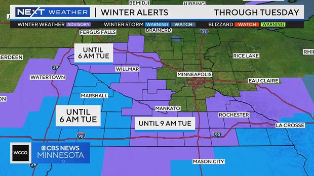
Weather Alerts Taking Effect Monday
Winter Weather Advisory: Southwestern Minnesota through 6 a.m. Tuesday; 3-5 inches of snow possible
Winter Storm Warning: Far southwestern Minnesota from Tuesday at midnight through 6 a.m.; 6-10 inches possible
Winter Weather Advisory: Southern Minnesota from 3 p.m. Monday through 6 p.m. Tuesday; 2-4 inches of snow and wind gusts of 35 mph
Snow Emergencies
As more snow is expected, there's already at least one city declaring a snow emergency: Elk River.
Overnight parking restrictions will go into effect from 2:00 a.m. Tuesday to 6:00 a.m. Nightly parking restrictions will remain in effect until the snow event has been lifted by city staff.
Check the latest school closings/snow emergency information.
Three Rounds Of Snow This Week
The first round of snow will fall in the Twin Cities until Monday night. The snow could create some slick spots around the metro.
Round two arrives later on Wednesday.
Round three arrives late Friday and lingers through Saturday.
All three rounds will drop light snow on the metro, with only about 3 inches of accumulation total expected.
Temps Steadily Plummet
Highs will be in the 30s until Wednesday, the 20s until Thursday, the teens on Friday and then single-digit highs and subzero lows for the weekend.
Saturday and Sunday will be NEXT Weather Alert days due to the season's first big blast of cold. Wind chills could bring feels-like temps near minus-20 degrees or colder at times.


