Is a hurricane coming to Florida? Tropical Storm Dolly remnants to bring risk of heavy rain, flooding


The final day of August is going to be hot and humid with more rounds of storms.
High temperatures are expected to climb into the low 90s, but it will feel like the upper 90s and the low 100s when you factor in the humidity.
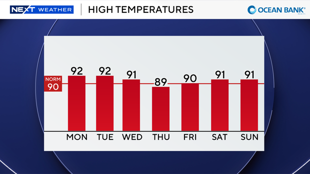
The heating of the day, along with plenty of moisture in the atmosphere, will lead to storms developing around midday, and this afternoon some of the thunderstorms that develop could be on the strong side.
Heavy downpours, localized flooding, lightning and gusty winds will all be possible.
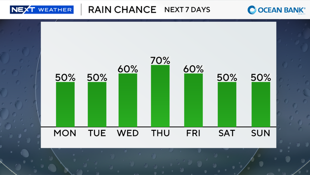
Rinse and repeat on Tuesday as it's expected to be a soggy start to the month of September. The chances of rain are rising mid- to late-week due to moisture associated with the remnants of what was once Tropical Storm Dolly.
Keep the rain gear close as we will see more widespread showers and thunderstorms with the potential for more downpours and localized flooding.
NEXT Weather team monitoring Gulf, Atlantic for possible tropical development
The CBS News Miami NEXT Weather team is tracking two areas in the tropics.
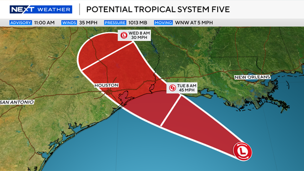
The National Hurricane Center classified an area in the Gulf as potential tropical system five.
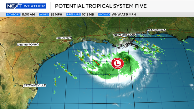
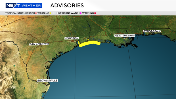
Tropical storm warnings are now in effect for the Upper Texas Gulf Coast, as well as for portions of Louisiana.
This continues to be a developing system in the northern Gulf that's expected to bring tropical storm conditions to the upper Texas and southwestern Louisiana coasts by Tuesday.
As of the 11 a.m. advisory, the system had maximum sustained winds of 35 mph and a central pressure of 1013 millibars. It was moving west-northwest at 5 mph.
A Hurricane Hunter aircraft and overnight satellite data support enough organization to begin advisories ahead of expected development.
A Tropical Storm Warning is in effect from Port Bolivar, Texas, to the Vermilion/Cameron Parish line in Louisiana.
Some strengthening is expected before landfall Tuesday, with sea surface temperatures above 86 degrees and weak wind shear across the system's path.
Because the system is small, forecasters say it could intensify quickly, and additional strengthening beyond the current forecast can't be ruled out.
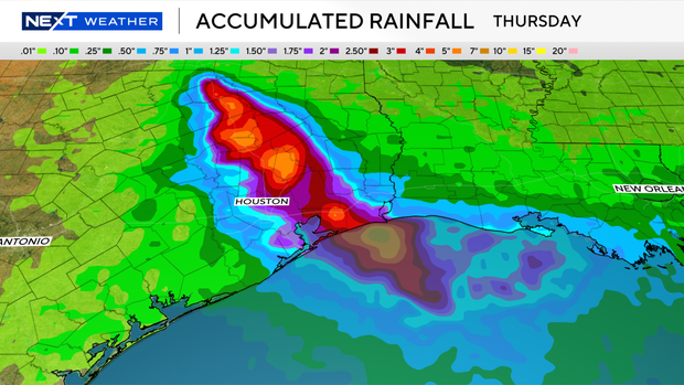
The bigger concern is rain.
Heavy rainfall and flash flooding are expected in urban areas from the upper Texas coast through east-central Texas and into far southwestern Louisiana Tuesday into Wednesday.
Some areas near Houston could see 4 to 7 inches, with isolated higher totals possible closer to the coast. Minor to moderate coastal flooding is also possible.
The system is forecast to move inland and weaken quickly, dropping to 30 mph winds and post-tropical status by Tuesday night into Wednesday, with dissipation expected by early Thursday.
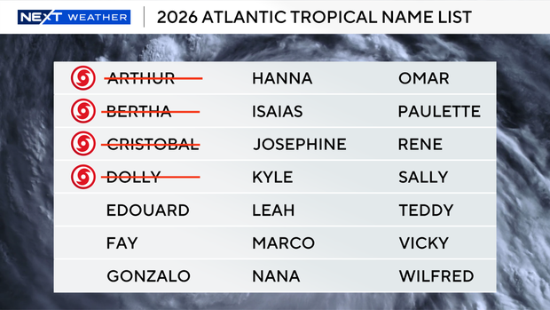
If the system strengthens into a tropical storm, it would be named Edouard.
The CBS Miami Next Weather team is also monitoring the remnants of Tropical Storm Dolly near Hispaniola.
This surface trough of low pressure remains disorganized and has a 10% chance of redevelopment.
The National Hurricane Center says that redevelopment, if any, would be slow to occur during the next few days as this system encounters unfavorable upper-level winds while moving quickly west-northwestward at 20 to 25 miles per hour.
Regardless of development, this system could bring heavy rain and gusty winds to portions of the Leeward Islands, the Virgin Islands, Puerto Rico, Hispaniola and the Bahamas during the next couple of days.
Here in South Florida, we can expect higher rain chances later this week due to all the moisture associated with this system moving in our general direction.