Heavy rain hits Broward as storms repeatedly move over the same areas


Storms are repeatedly moving over the same parts of Broward County Tuesday evening, raising the threat of additional street flooding across parts of South Florida.
The National Weather Service extended a flood advisory for northern Broward County until 7 p.m. as heavy rain continued to fall across the area.
As of 6:05 p.m., Doppler radar indicated that 1 to 3 inches of rain had already fallen, with another 1 to 3 inches possible. Minor flooding was ongoing or expected to begin shortly, particularly in low-lying areas and places with poor drainage, the NWS said.
CBS Miami NEXT Weather meteorologist Nic Merianos said storms are "training," a term used when storms repeatedly move over the same areas and produce prolonged periods of heavy rain.
More street flooding is likely to develop in this setup, Merianos said, with Plantation, Davie and Pembroke Pines among the areas of particular concern.
The NWS said areas that could experience flooding include Coral Springs, Sunrise, Tamarac, Margate, Lauderhill, Coconut Creek, North Lauderdale, Lauderdale Lakes, Parkland, Broadview-Pompano Park, Godfrey Road, Palm Aire, Village Park and Ramblewood East.
The flooding threat comes after another soggy day across South Florida, where deep tropical moisture has fueled widespread storms and heavy downpours.
The Weather Prediction Center placed South Florida under a marginal, or Level 1, risk of flooding Tuesday.
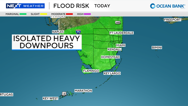
The ground is already saturated from recent rainfall, meaning additional heavy rain could quickly lead to flooding. Some areas could receive an additional 1 to 2 inches of rain, with isolated amounts of 3 to 5 inches possible along the east coast metro areas.
High temperatures Tuesday were expected to reach the upper 80s because of the clouds and wet weather.
Tuesday also marks the start of astronomical fall, with the autumnal equinox taking place at 8:04 p.m.
The equinox occurs when the sun crosses directly above Earth's equator, moving south. The word "equinox" comes from Latin words meaning "equal night," because day and night are nearly equal in length.
Daylight hours will continue to grow shorter and nights longer until the winter solstice in December.
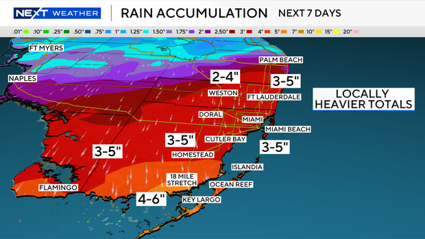
The chance of rain remains high Wednesday and Thursday, with scattered to numerous storms likely.
Rain chances are expected to decrease slightly late in the week and through the weekend, although passing storms will remain possible. Some drier air is forecast to move in by late weekend into early next week, helping lower rain chances, humidity and temperatures.
The CBS News Miami NEXT Weather team is also tracking Tropical Storm Fay in the Atlantic, which is expected to weaken into a post-tropical cyclone over the next few days.
A tropical wave is expected to move off the coast of Africa and has a low chance of development over the next seven days.