Hot, humid conditions to fuel strong storms and flash flood threat across South Florida

South Florida residents can expect another hot and humid day Sunday, with triple-digit heat index values developing across much of Miami-Dade and Broward counties before scattered afternoon and evening storms bring the threat of heavy rainfall and localized flooding.
High humidity levels, ranging from the mid-70% range in Miami and Fort Lauderdale to more than 80% in Homestead, will combine with temperatures near 90 degrees to make it feel significantly hotter. Heat index values are expected to reach 100 to 102 degrees across inland portions of both counties, including Plantation, Davie, Miramar, Lauderhill, Doral and Miami Lakes. Coastal areas such as Miami Beach, Aventura and Fort Lauderdale are expected to feel closer to the upper 90s.
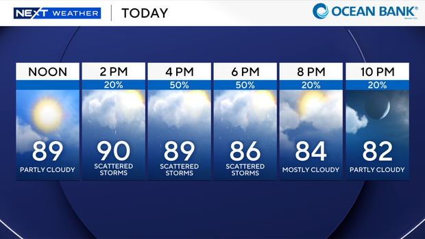
Rain chances will remain low through midday before increasing during the afternoon. Forecasts call for a 20% chance of storms by 2 p.m., rising to 50% by 4 p.m. and remaining elevated through the early evening hours. Temperatures are expected to peak near 90 degrees before falling into the mid-80s after sunset.
Tropical moisture moving into the region will interact with daytime heating to produce scattered thunderstorms, some of which could become strong and generate isolated heavy downpours. The greatest threat is expected during the late afternoon and early evening.
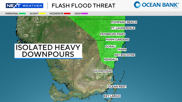
Because of the potential for intense rainfall, the Weather Prediction Center has placed South Florida under a Level 1, or marginal, risk for excessive rainfall and flash flooding. While widespread flooding is not expected, localized street flooding could occur where the heaviest storms repeatedly move over the same areas.
The unsettled weather pattern is expected to continue through much of the upcoming week.
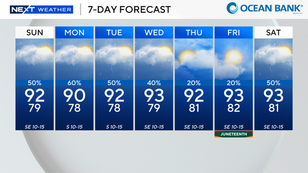
Rain chances remain elevated at 40% to 60% from Sunday through Wednesday, with highs generally in the low 90s. Thursday and Friday currently appear to be the driest days of the week, with rain chances dropping to around 20%, before another increase in storm activity is possible next weekend.
Due to the high temperatures, residents should stay hydrated, limit strenuous outdoor activity during the hottest part of the day and remain alert for rapidly changing weather conditions during the afternoon and evening commute.