El Niño could exceed previous events from 1950. Here's what Southern California residents should know.
The National Oceanic and Atmospheric Administration's Climate Prediction Center says there is greater than a 90% chance that a "very strong" El Niño event will take place in the Northern Hemisphere during the fall and winter of 2026 and 2027, which could bring one of the wettest winters in years to Southern California.
"During the October-December 2026 season, there is a 69% chance of a historic event that would exceed the strength of previous El Niño events dating back to 1950," according to NOAA's Climate Prediction Center.
Living in Southern California means residents must be prepared for myriad weather events, including heavy rainfall and flooding.
While it is difficult to predict the onset of an El Niño event, forecasters can reasonably predict its intensity and evolution, according to NOAA. With this information, officials across the Southern California region are already beginning to prepare for the potential impacts of El Niño.
According to NOAA, ENSO, which includes La Niña, is arguably one of the most influential climate drivers on Earth. Even if there are no substantial impacts in Southern California, there could be in other places across the world.
What is El Niño?
El Niño occurs when there are unusually warm ocean temperatures in the Equatorial Pacific Ocean. The surface waters across the tropical Pacific Ocean are warmer by 1 to 3 degrees Celsius, compared to normal. This may sound small, but tiny changes in ocean temperature can make a big difference.
The warmer water causes moisture to build in the atmosphere, increasing the chance of rainfall and storms over the Eastern Pacific. The development of these thunderstorms in this region can change or alter the weather patterns around the globe, affecting the weather in Southern California.
"El Niño exerts its largest impacts on the Northern Hemisphere during the winter, typically bringing milder weather to the northern parts of the United States and wetter conditions across the southern United States," according to NOAA.
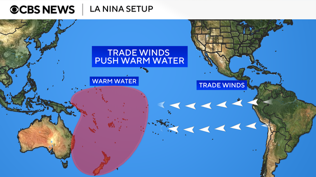
The driving forces behind El Niño and La Niña are the trade winds. Under La Niña, they blow from east to west, pushing warmer water into the western Pacific, closer to Australia. Every now and then, the winds reverse, going from west to east, piling the warmer water up closer to South America. The reversal of the winds is what brings an El Niño.
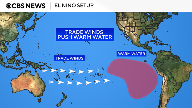
Weather officials say an El Niño typically occurs every two to seven years. NOAA is responsible for declaring when an El Niño or La Niña event has begun in the U.S.
Not all El Niños are the same. Some are weak, moderate, strong and others are very strong.
According to data from the National Weather Service, one of the region's strongest El Niños was in 1997-1998. On average, the region receives 14.25 inches of rain during the water year, which runs from October to September. During the 1997-1998 water year, the region received 30.57 inches of rain.
Another powerful El Niño occurred during the 1982-1983 water year. The region received a total of 33.19 inches during that year.
What is La Niña?
La Niña is the opposite of El Niño. It occurs when there are unusually cool ocean temperatures in the Equatorial Pacific Ocean. The surface waters across the tropical Pacific Ocean are cooler by 1 to 3 degrees Celsius, compared to normal.
During a La Niña, trade winds blow strongly from east to west across the Pacific Ocean, causing the warmer water to get pushed toward Asia and Australia.
El Niño's potential impacts on Southern California
According to NOAA, while most of El Niño's impacts are felt in the tropical parts of South America, it can also have destructive effects in the U.S.
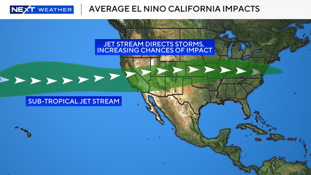
Since El Niño shifts weather patterns and the paths storms take, this increases the chances that winter storms hit Southern California more often. With a chance for more storms comes a higher risk of heavy coastal erosion, flash floods and mudslides, particularly in foothill communities and near burn scar areas.
El Niño brings together the ingredients for storms in Southern California more often compared to La Niña, according to weather experts. That doesn't guarantee a storm, but increases the chances one will occur.
For example, the winter of 2015-2016 brought a strong El Niño, but rain did not materialize in California.
Southern California officials prepare for El Niño
Kerjon Lee, the chief of strategic communications at the Los Angeles County Department of Public Works, said officials have been preparing for the potential impacts of El Niño for months.
"We see this storm season and every storm season as kind of like our Super Bowl," Lee said. "So, we are preparing year-round, not just a month or even two months ahead of time to make sure our facilities are ready for the upcoming storm season."
The Department of Public Works, which is one of the country's largest public works agencies, is responsible for operating and maintaining regional infrastructure. One of the department's biggest roles is managing flood control and protection.
The county's massive flood control system was created in part to reduce the risk of stormwater flooding.
Lee says the department is already working to prepare debris basins and reservoirs for the potential rainfall, especially in the burn scar areas, which are more prone to debris flows. Lee also added that crews are clearing sediment and boulders to help prevent dangerous mudslides.
In September, Lee says the county will launch a comprehensive public outreach campaign reminding residents of the steps they can take to prepare their homes and properties before a storm comes.
Lee says one of the biggest things residents need to know from now on is their flood risk. He recommends residents use the Federal Emergency Management Agency's Flood Hazard Map, where they can enter their address to better understand their level of flood risk.
"For homes, if you find that you're in an area that has high flood risk, we really strongly advise residents to invest in flood insurance," Lee said.
How can residents prepare for El Niño?
The Department of Public Works says residents should begin preparing for El Niño now and not wait until it's too late.
Steps residents can take now:
- Know your risk: Check out FEMA's Flood Hazard Map service center. Ready.lacounty.gov/rain.
- Sign up for alerts: Stay notified of emergencies by registering for Alert LA County and NOAA Weather Radio.
- Consider flood insurance: Standard homeowners' insurance does not cover flood damage – that's a separate policy. With less than 2% of California homes insured against floods, an El Niño winter is a timely reminder to explore coverage through FEMA's National Flood Insurance Program.
- Make a family emergency plan: Before the rainy season, prepare a household plan covering emergency alerts, a multi-day supply kit, utility shut-off locations, and an evacuation route with arrangements for children, pets, and mobility-impaired family members.
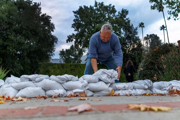
- Protect your property: Clear gutters, downspouts, and nearby storm drains of leaves and debris, and inspect your roof for leaks so your home is ready to handle heavy rain. Use the Public Works Sandbags Dashboard to find the nearest fire station or beach location providing sandbags.
- Prepare for mudflows: Before storms arrive, place sandbags, board up windows, and direct flows away from structures rather than damming them. This is especially critical in recent burn areas.
- Stay informed: Continue monitoring trusted sources and emergency alerts throughout the storm.
Patrick Wright contributed to this report.


