Tropical Storm Marco Quickly Approaching US Landfall With Laura Following Right Behind
(CBSDFW.COM) - On Monday, Tropical Storm Marco will strike the delta of Louisiana, just south of New Orleans. It is forecast to deliver 75 mph winds and produce 4 to 5 feet of storm surge into an area already struggling with decades of erosion and loss of land.
Marco was downgraded to a tropical storm Sunday evening after it became a hurricane earlier in the day. However, it is expected to strengthen again Monday.
Hurricane warnings are out as the storm approaches. This will make the sixth named storm and third hurricane to hit the U.S., all of this happening before Sept. 1 and at the halfway point of the Atlantic hurricane season.

But, of course, that isn't most remarkable statistic on what is about to happen. It appears that a mere 48 hours after Marco hits, a powerful hurricane Laura (currently a tropical storm) will strike somewhere near Port Arthur.
This would be the closest arrival times between two hurricanes in the recorded history of the Gulf of Mexico (records go back to 1851). Also of note, it appears that the two storms will cross paths twice, once in the open water and the another time over land.
The path of Laura is still very much in the air because of how the storm will interact over the area in the Gulf already passed over by Marco 48 hours earlier. Stay tuned.
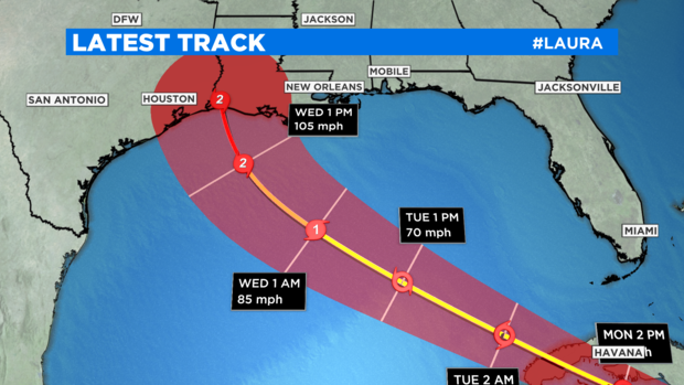
The further Laura gets pushed southwest across the Gulf the stronger of a storm it will become. The season has yet to see a major hurricane in the Atlantic or Gulf. I suspect that Laura will come close.
How will these storm affect North Texas? I'm playing a stronger hand on this, going with highs in the low 90s and 40 to 50% rain chances on Wednesday.
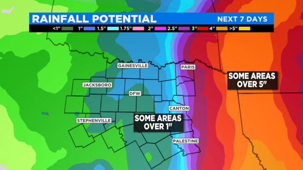
The first chance of much needed rain (this is the driest start to August in ten years) happens in the morning hours of Wednesday and continues through the day. Marco now appears to be passing closer to Houston and we'll be in the northern range of the rain bands.
Laura looks to move quickly over Louisiana on Thursday, creating a dramatic rain gradient across East Texas. Our eastern counties could get 1 to 2 inches of rain; part of Louisiana just 100 miles to the east could get over 5 to 7 inches.
Keep a close watch to the forecast over the next couple of days. Tropical Storm Laura is forecast to become a hurricane on Tuesday or Wednesday and then strengthen rapidly.
If it keeps its current track it could do severe damage to the oil and gas refineries in Port Arthur, one of the top petroleum producing areas in the country.
If the storm actually lands in Texas, it could dramatically change our rain forecasts here.