Tracking weekend storms and a sunny Sunday in Southeast Michigan

If you have outdoor plans to kick off the weekend across Southeast Michigan, you will want to keep an eye on the radar.
Here is a breakdown of what to expect from Friday night through Sunday.
Expect a soggy start to the weekend.
We are tracking scattered showers and thunderstorms moving across Metro Detroit much later this Friday evening.
The most active window for rain and rumbles of thunder will be between 4 p.m. and 10 p.m. for basic showers, and through 5 a.m. for storms.
While most severe weather is not expected tonight, some storms could bring localized heavy downpours and gusty winds.
In addition, our humidity creates a very dense airmass, so any thunder will be a bit louder than normal due to the ease with which the air can vibrate.
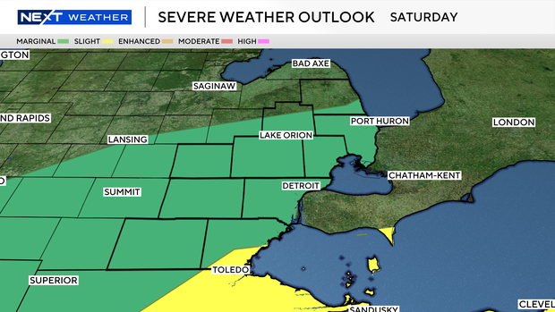
Saturday will not be a total washout, but you will need to stay weather-aware.
As a weak cold front moves through the area, it could spark another round of scattered showers and thunderstorms by early afternoon.
A few of these isolated storms could pack a punch.
The main threats will be gusty winds and hail, with the highest chances for stronger storms focused closer to Lake St. Clair and Lake Erie.
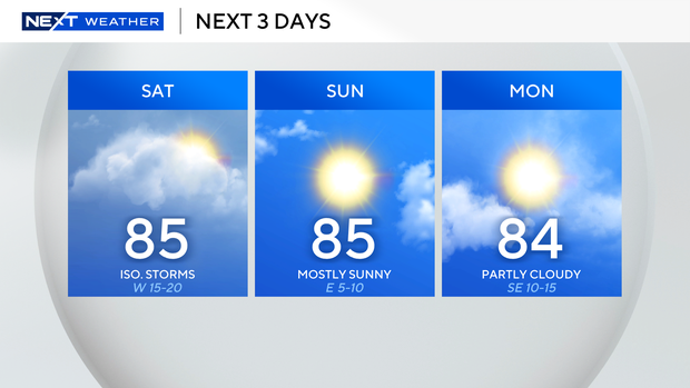
High temperatures will climb into the mid-to-upper 80s, making it feel quite warm and muggy.
If you are heading out to the lake or running errands, just have a backup indoor plan ready for the afternoon.
Sunday is shaping up to be the clear winner this weekend.
Dry weather returns as high pressure builds back over the region, bringing plenty of sunshine to Southeast Michigan.
With light breezes out of the northeast and lower humidity, it will be a beautiful, albeit warm, day to get outside before a much hotter and stormier pattern takes over the work week.