First snow storm of the season expected to hit Southeast Michigan this weekend
The first winter storm of the season is expected to hit Southeast Michigan on Saturday.
The CBS News Detroit NEXT Weather team has called for a NEXT Weather Alert Day for Saturday.
Let's start with the usual response of 'It's Michigan; it's supposed to snow.'
That's correct, but that doesn't mean snow isn't still an issue that needs to be discussed, especially when a larger event is expected.
A large area of low pressure to the southwest will move east and then northeast through the region this weekend.
While the exact track still has a few small questions to it, there is enough of a sign for snowfall that we need to break down the info we have.
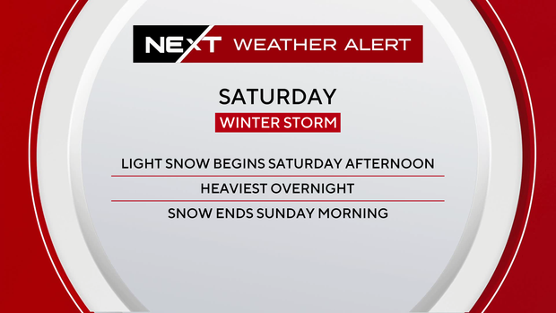
Light snow begins Saturday afternoon, mainly after 4 p.m. By 8 p.m. Saturday, snow will be accumulating, and the system will have arrived in earnest.
Snow will be at the heaviest rates Saturday overnight, especially around 2 a.m., before tapering off by 9 to 10 a.m. Sunday.
Snowfall amounts will change, but not by drastic amounts.
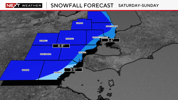
We expect a broad coverage of 4 to 8 inches of snowfall, with lighter amounts of 3 to 5 inches downriver and in eastern Monroe County. Three to 6 inches are possible along the river and north to the Lake Huron shoreline, but this number may change.
Suffice to say, travel will be an issue on Sunday morning and potentially a little longer into the day as road crews work to clear the surfaces.
This snow will also be sticking around as temperatures fall next week to kick off the month of December.
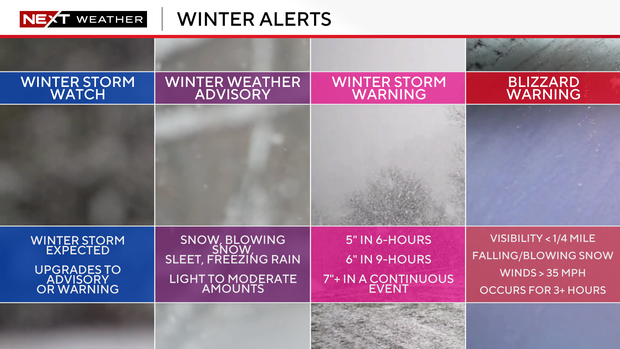
We await to see if the National Weather Service will issue a winter storm watch for Southeast Michigan, but in the meantime, it's important to know what each type of winter headline is.
A winter storm watch is issued when a true winter storm is expected and is the initial "heads up" for people; this is upgraded to an advisory or warning.
A winter weather advisory means you will see light to moderate amounts of winter precipitation, usually with an impact on commutes but not a full-day issue.
A winter storm warning means a winter storm that is likely to cause hazardous travel or larger issues is expected.
In this case, snow will fall either five inches in six hours, six inches in nine hours, or seven inches or greater in a continuous event.
A blizzard warning really doesn't depend on snow amounts but rather on the combination of strong winds and snowfall rates.
Wind stronger than 35 miles per hour, low visibility below 1/4 mile, and falling snowfall are needed for one of these alerts, and it must last for three or more hours to be considered a blizzard.
I expect a watch to be issued before the system arrives and a possible advisory near the state line, with winter storm warnings possible elsewhere if the amounts hold as expected.
Stay with the CBS News Detroit NEXT Weather Team for updates on conditions and the forecast as we get closer.