Humidity Strikes: Temperatures Could Feel Like 102º In Metro Detroit
DETROIT (WWJ) - The heat is on in metro Detroit — and it's going to be a muggy one.
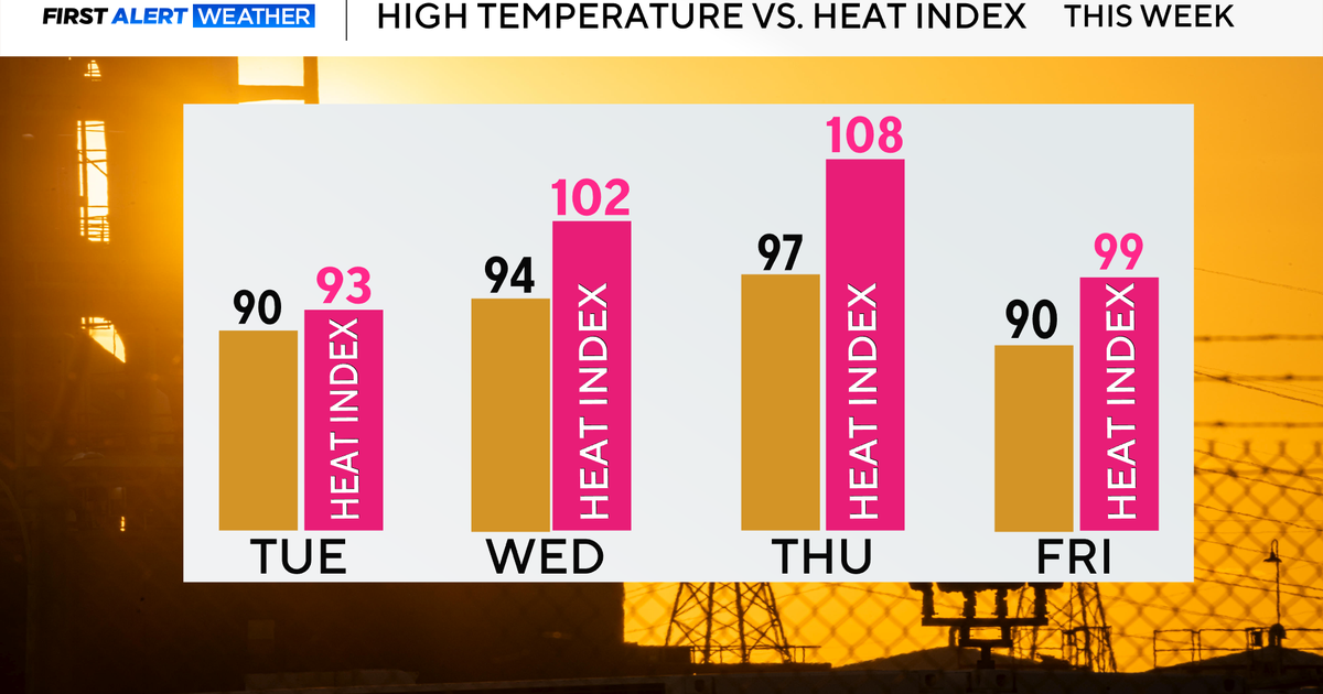
AccuWeather Meteorologist John Feerick says while temperatures will top out in the low-to-mid 90s on Wednesday — the real feel temperature will surge past 100º to as high as 102º in Southeast Michigan.
Along with the heat, expect it to be sticky and humid out there, Feerick says, with scattered storms possible through Saturday.
Wednesday, meantime, marks the 8th Ozone Action Day of the year for our area — which means the potential for elevated ozone is very likely. Clear skies and strong solar radiation also encourage ozone growth.
"Certainly that's a concern," Feerick told WWJ's Jackie Paige. "Air quality (will be) a little bit worse than usual, simply because the air's pretty stagnant. So you'll want to limit those outdoor activities if you can...Definitialy make sure you stay hydrated and wear light-colored clothing as much as you can outdoors."
Southeast Michigan Council of Governments (SEMCOG) says with the likelihood of a tougher ozone standard being put into place next fall, it is more important than ever that local governments, businesses, and the general public do what they can do to voluntarily lower pollutant emissions on Ozone Action days.
SEMCOG is asking area residents to do the following:
- Delay mowing your lawn until evening or the next day. Exhaust from your lawn mower and other gas-powered lawn and garden equipment help form ozone.
- Avoid refueling your vehicle during daylight hours. Fumes released at the gas pump contribute to ozone formation.
- Limit travel. If possible, carpool, vanpool, take public transit, walk, bike, or telecommute on Ozone Action days.
- Reduce electricity use. Adjust your thermostat a few degrees higher and turn off lights, computers, and other electrical devices when not in use.
Feerick says it'll be just as hot and humid on Thursday with a thunderstorm possible and hot and humid again on Friday, with more storms in the forecast. Temperatures drop a bit over the weekend with a less hot — but still quite humid — Saturday in store, along with more storms.
Here's the detailed forecast from the CBS Detroit weather team: