Extreme heat expected to cover Southeast Michigan next week. What to know.

Extreme temperatures are on the horizon in Southeast Michigan, setting the stage for a prolonged and dangerous heat wave next week.
High temperatures beginning Monday will reach 90 degrees, and starting Tuesday will exceed this level.
From Tuesday through Friday, highs will be in the mid- to upper 90s each day, with dew points in the 70s. At levels like this, the heat index reached dangerous levels for those of us in southeast Michigan.
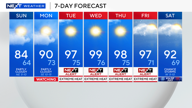
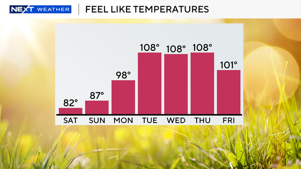
We simply do not see heat like this often, and a heat wave of this level is quite rare. The heat index from Tuesday through Friday will be well above 100 degrees, potentially reaching 110 on Wednesday and Thursday.
As a matter of fact, both Wednesday and Thursday could potentially reach near 100 degrees for the air temperature. If they both make it, this would be the first consecutive 100-degree days since the 1980s.
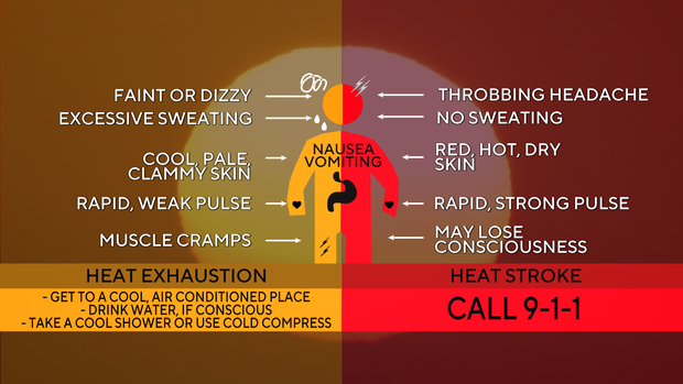
The heat risk from the National Weather Service is classified as "extreme" due to its rarity, prolonged nature, and the difficulty of recovering from heat without air conditioning. That is the biggest issue: the continuous nature of the excessive heat and humidity.
Your body cannot cool itself off without some external cooling source in temperatures and heat indices like we will see next week. This is where breaks in the air conditioning are extremely important; fans alone will not work.
Because there is so much moisture in the air, your sweat will not evaporate fast enough to naturally cool your body. At this point, both heat exhaustion and heat stroke become a concern.
In a heat wave like the one we should see next week, heat exhaustion can occur in as little as 15 minutes with direct, continuous heat and work. To recover from that much exposure, the Centers for Disease Control and Prevention recommends 45 minutes of air conditioning time.
Staying hydrated is also key, so make sure to drink plenty of water.
The NEXT Weather Team has labeled Tuesday through Friday as NEXT Weather Alert Days due to the hazards. Stay with the weather team for updates as we continue to monitor the heat and associated risks.