Why So Much Snow? Summer-Like Wind Pattern Brings Denver Biggest Snow In Years
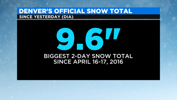
DENVER (CBS4) - Most residents in the Denver metro area woke up to 6-12 inches of snow Thursday morning. Instead of the heaviest snow falling in the foothills as expected, a shift in the wind pattern Wednesday evening caused the biggest 2-day snow total in Denver since 2016.
RELATED: Some Denver-Area Schools Close, Others Delay Start Or Move To Remote Learning After Pileup Of Snow
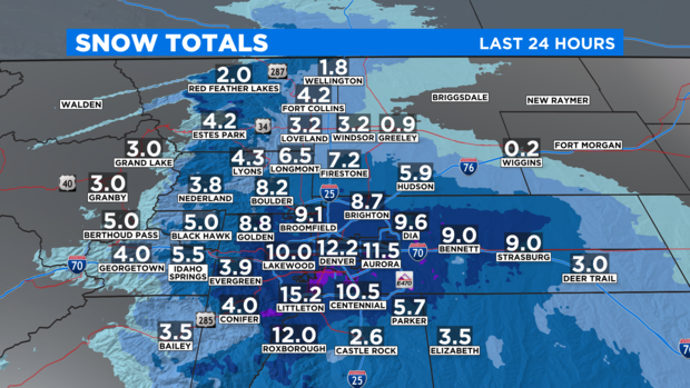
Western sections of Arapahoe County received the most snow with a "bullseye" around Englewood, Cherry Hills Village, and Littleton.
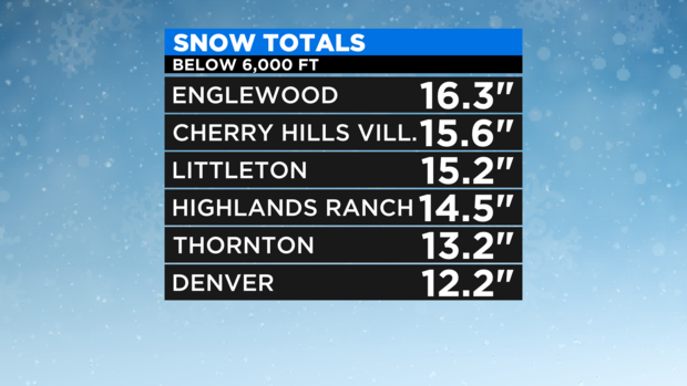
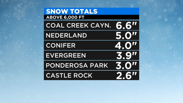
Ironically, areas above 6,000 feet south and west of Denver saw much lower snow totals. These areas almost always get more snow than Denver with the type of storm that hit late Wednesday.
Officially Denver received 9.6 inches of snow which is the largest 2-day snow total in the city since April 16-17, 2016. The storm has completely erased the previous snowfall deficit for the season. Denver has now received 13.5 inches of snow this February and 33.6 inches this season.
Elsewhere, snow totals ranged 1-4 inches around Fort Collins, Loveland, and Greeley to 2-4 inches at most ski areas Colorado.
So why did the Denver metro area get so much more snow than the foothills? The answer resides in the wind pattern that ultimately setup along the Front Range Wednesday evening.
With the center of the storm over the Four Corners region, Denver and the Front Range was expected to get a easterly wind. Normally this easterly flow would hit the foothills west of the metro area and be forced upward. The forecast was for this this upward motion to generate the heaviest snow in the foothills and along the Palmer Divide (above 6,000 feet) in Douglas and Elbert Counties. But in reality, it wasn't just an easterly wind that materialized Wednesday night. Instead, winds were coming from two directions: the easterly over the east half of the metro area, northwest winds over the west half of the metro area. When the east wind encountered the unexpected northwest wind, it set up a "convergence" zone directly over the Denver metro area. Over time, this area of converging wind became the bullseye for snow instead of the higher terrain west and south of the city.
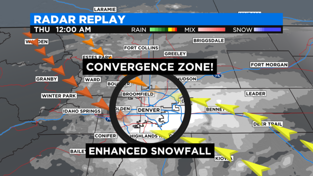
This local weather phenomenon is often called the "Denver Convergence Vorticity Zone" or DCVZ. It's most common in the warm weather months and is often responsible for helping to trigger afternoon thunderstorm and brief tornados on the southeast side of the metro area. It's rare to see the DCVZ impact winter storms.
Meanwhile, the mountains were not expecting to get much snow and generally they did not. All ski areas in Colorado measured less snow than Denver Thursday morning. The ski areas will do better with the next storm approaching for the weekend. Fresh powder is expected for virtually all ski areas on Saturday. Denver may get a few flurries or isolated light snow showers late Saturday but no accumulation is expected.