Denver Weather: A Drier And Brighter Pattern Is Finally Developing For Colorado
DENVER (CBS4) - In a state that enjoys bragging about how much sunshine usually covers the state, it sure has looked different lately. After a long stretch of mostly cloudy and wet weather, sunshine finally returned to the Front Range Wednesday morning.
There is still a chance for showers and thunderstorms in the metro area late in the day Wednesday, but the chance is considerably smaller compared to recent days.
It will also turn noticeably warmer for the remainder of the weekend and for the upcoming weekend. After a high temperature of only 58 degrees on Tuesday (Denver's normal high temperature in late March), Wednesday will be at least 15 degrees warmer.
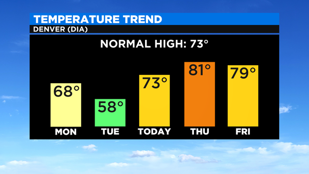
The warming trend will continue into Thursday and Friday with high temperatures on either side of 80 degrees to finish the week.
The showers and thunderstorms that may cross over Denver and the Front Range late Wednesday will initially develop in the higher foothills and mountains west of the urban corridor. These areas have the poential for some brief heavy rain and even some snow above tree line again.
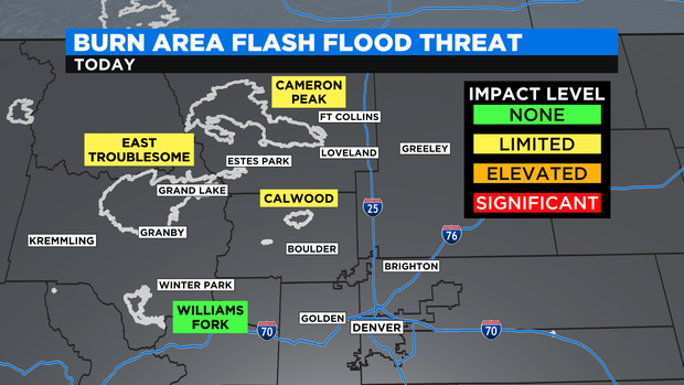
While the threat for flash flooding is low over the 2020 wildfire burn scars but there is a limited chance for flooding for the scars in Grand, Larimer, and Boulder Counties including East Troublesome, Cameron Peak, and Calwood.
Enough dry air should reach Colorado on Thursday so severely limit thunderstorm chances almost statewide. There will still be a slight chance for storms mainly in the mountains.
Then a somewhat better chance for late day showers and thunderstorms will return for Friday and the weekend but chances will remain much lower compared to last weekend and earlier this week.