Denver Weather: Our Coolest Day In More Than Four Months
DENVER (CBS4) - October starts very different compared to September which was officially the second warmest on record in Denver. Instead of unusually warm temperatures under sunny skies, Tuesday will be the coolest day since May in the metro area under cloudy skies, drizzle, and fog.
The Denver, Boulder, and Fort Collins area will start the day in the 50s and end the day in the 50s. It will be 20 to 25 degrees cooler than Monday and nearly 15 degrees below normal for October 1.
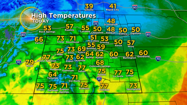
But while eastern half of the state experiences a very cool day, the mountains and Western Slope will enjoy sunshine and warmer than normal temperatures. The reason is two distinct airmasses over Colorado. The airmass over the western half of the state will bring westerly winds while in the east it will be a northeasterly wind bringing cool, moist air. This is why the weather will be dramatically different roughly east and west of the Continental Divide.
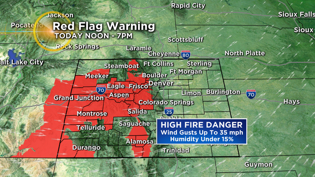
The warmer weather west will also keep the fire danger high. With several fires burning in Colorado including in Chaffee County near Salida, another Red Flag Warning has been issued from noon until 7 p.m. on Tuesday. Westerly winds will gust up to 35 mph along with reality humidity staying under 15%.
Meanwhile, along the Front Range and the Eastern Plains drizzle is likely but any measurable rainfall will be limited. The best chance for precipitation in the metro area will be early in the day and then Tuesday night into very early Wednesday.
The clouds will finally clear by early afternoon on Wednesday and then sunshine will prevail for the remainder of the week with gradually warming temperatures.