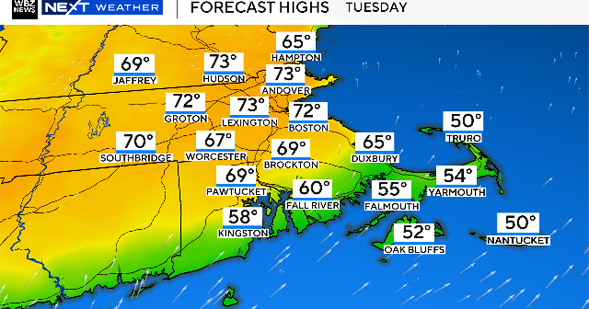
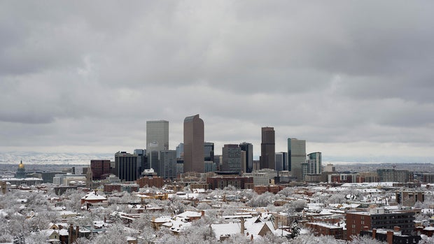
Denver's first snowfall continues to be delayed, nearing a record-late start

Denver's wait for the first measurable snow of the season continues. The Mile High City is now 18 days behind the average first snowfall date and is on pace for a top ten latest start since records began in 1882.
Forecast models show little hope in the short term. Over the next 10 days, only one weak disturbance may bring very light snow to the northern mountains, but none to the Denver metro area.
With a high degree of confidence, Denver will remain snow-free through Nov. 15. That would tie for the sixth-latest first measurable snowfall on record.
Right around Nov. 15 - 19, there is a slight chance of a disturbance moving through Colorado. If that system fails to materialize, Denver would move into the top five for latest first snow on record.
There's no need to panic, though. Historical data show no clear correlation between a late first snowfall and a below-average snow season in Denver.
Below are the latest first snowfall dates for Denver since 1882 (at least 0.1" recorded):
1. Dec. 10, 2021 = amount 0.3"
(2021's seasonal snowfall = 49.4")
2. Nov. 21, 1934 = amount 1.0"
(1934's seasonal snowfall = 48.3")
3. Nov. 19, 1931 = amount 1.0"
(1931's seasonal snowfall = 55.4")
4. Nov. 17, 2016 = amount 1.7"
(2016's seasonal snowfall = 21.8")
5. Nov. 16, 1894 = amount 2.6"
(1894's seasonal snowfall = 37.0")
6 (tie). Nov. 15, 2010 = amount 1.5"
(2010's seasonal snowfall = 22.8")
6 (tie). Nov. 15, 1988 = amount 2.5"
(1988's seasonal snowfall = 50.1")
6 (tie). Nov. 15, 1987 = amount 6.1"
(1987's seasonal snowfall = 62.3")
6 (tie). Nov. 15, 1902 = amount 4.0"
(1902's seasonal snowfall = 45.6")
7 (tie). Nov. 14, 2008 = amount 0.1"
(2008's seasonal snowfall = 38.1")
7 (tie). Nov. 14, 1964 = amount 4.2"
(1964's seasonal snowfall = 55.9")
7 (tie). Nov. 14, 1944 = amount 0.1"
(1944's seasonal snowfall =51.6")