Colorado Weather: Here's Your Wind Outlook For The Week Of April 24
DENVER (CBS4) - After weeks and weeks with bouts of constant high wind, we've decided to give you a wind outlook for the week ahead to help you make your plans. Unfortunately, it isn't the news you probably want to hear.
Sunday will be the coolest day of the week ahead, and we'll still have some wind, but the speeds should be lower than Saturday. We'll call it breezy instead of windy. Snow is expected in the mountains with the potential for a few evening showers around metro Denver.
RELATED: Colorado Weather: Mountain Snow Sunday, Turning Cloudy With A Few Evening Showers In Denver
Monday is looking like it will be the calmest day of the week ahead with mostly light wind speeds expected. Temperatures will be a little warmer than Sunday, but not by much. If you want those really warm readings you'll have to wait a few more days.
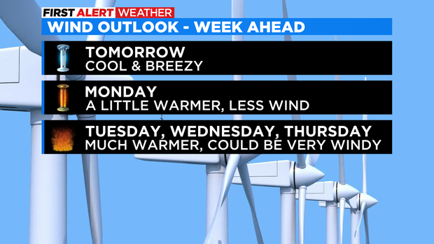
As we move into Tuesday, Wednesday and Thursday, a new storm system will drop into the western United States. Ahead of it, our temperatures will warm significantly, and that means fire danger will climb back to critical levels for many areas.
Much like we've seen in recent weeks, this storm looks like it will pass to the north of Colorado. That means it'll be close enough to produce periods of strong and gusty wind. Sadly, it's taking the wrong path to create any widespread and much needed rain or snow. Of course what's life without hope! This is a few days away and there is always a chance the pattern could change.
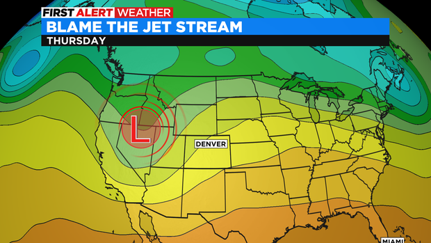
The jet stream is to blame for the long stretch of windy, mostly dry weather. As long as it is overhead or nearby, you will have wind. Add in vast temperature contrasts on either side of the jet, and the wind only increases.