Colorado Weather: Mountain snow on Monday unlikely to reach the metro area
A storm bring healthy snow to the northern mountains of Colorado will cause occasional wind on the urban corridor but likely no moisture.
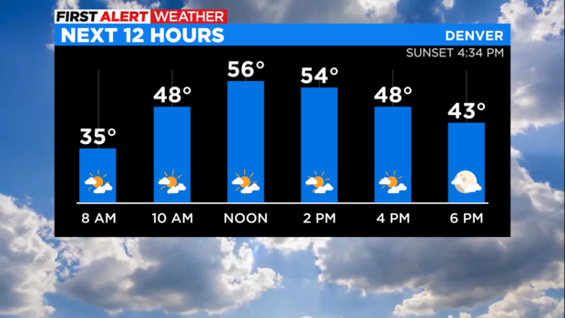
The cold front associated with the storm will pass over Denver around lunchtime on Monday. Temperatures will reach into the 50s before the front arrives and will then be in the 40s by late afternoon. Wind gusts could reach up to 30 mph at times especially west of Interstate 25.
Eventually a few sprinkles or flurries could develop after dark around Denver, Boulder, and Fort Collins but the chance for any measurable precipitation is very small.
It's a different story in the mountains where heavy snow and wind will impact most mountain areas north of Interstate 70 during day on Monday followed by areas farther south by Monday night.
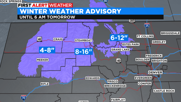
The mountains surrounding Rabbit Ears Pass, The Flat Tops and the Rocky Mountain National Park region are under a Winter Weather Advisory through 6 a.m. Tuesday. The Craig and Meeker areas should expect 4-8 inches of snow, the Steamboat Springs area will get 8-16 inches, and the higher terrain around Grand Lake and Estes Park will get up to 1 foot of snow.
Additional light snow will fall in the mountains on Tuesday before another surge of snow in the high country Wednesday night into Thursday. A few flurries could once again reach Denver and the Front Range but no accumulating snow is expected this week at lower elevations.