Colorado to see a cooler Sunday before workweek warmup

A cold blast of Arctic air dropped just to the east of Colorado. Since the eastern half of the state is right on the edge, temperatures will be cooler on Sunday.
After a cold start with temps in the teens and 20s, the metro area will warm into the upper 40s, near 50 degrees. Mountain towns will see highs in the 50s as they will not be as affected by the cold airmass.

This cold blast is just cold air, and we will not see any rain or snow.
The chilly weather doesn't last very long. Monday morning will start off chilly again with temperatures in the teens and 20s.
You'll want layers as you head to work or send the kids to school. In the afternoon, high temperatures will quickly warm to near 70 degrees for the Front Range, with temperatures near 60 in the mountains.
The workweek will see high temperatures in the 60s and 70s. Winds could be an issue on Tuesday and Friday, which will increase our fire danger.
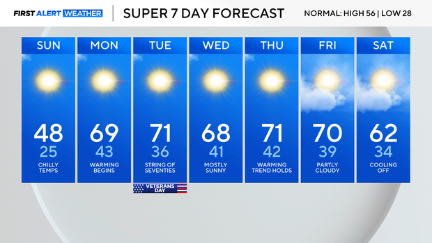
We are tracking a system next weekend that could bring snow. The mountains will likely see snow and there is a chance the Front Range and plains could get some snow Sunday and/or Monday. It's too far off to be certain of Denver snow, but we will continue to track the possibility through the week.