UChicago students use historic maps, state-of-the-art technology to bring Chicago neighborhood history to life

The histories of some pieces of land in Chicago are well-known.
The Thompson Center in the Loop stands on the former site of the Sherman House Hotel. The Chicago Police Belmont Area Headquarters and DePaul College Prep occupy land where one once would have found the thrill rides and sideshows of the Riverview amusement park.
Regenstein Library, that brutalist behemoth on 57th Street that's just that's just a little out of step with the rest of the University of Chicago campus, stands on the site of the original Stagg Field, the setting not only for football games, but most famously for the first sustained nuclear reaction in 1942.
But what about something a little more obscure, like a neighborhood business strip, or residential block, or even the very house where you live? Finding those histories poses a much greater challenge that can't be accomplished with a simple web search or AI inquiry.
A project at the University of Chicago is setting out to change that, using massive century-old maps housed at Regenstein Library and state-of-the-art machine learning. The goal of the Chicago Urban Heritage Project is far more than just to satisfy curiosity about the history of a given piece of property; it's filling in blanks for the history of entire neighborhoods and Chicago as a whole, through cycles of demolition and rebuilding, disinvestment and gentrification.
The Chicago Studies program at the University of Chicago spearheaded the project, working with the Center for Digital Scholarship at the UChicago Library.
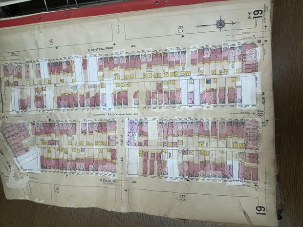
The project uses Sanborn fire insurance maps — large-scale historical maps that went into minute detail about each building on each block in Chicago and thousands of other cities and towns. The maps were made at various points in the 20th century; some even date back to the 19th. Student researchers use machine-learning software to digitize the information on the maps and develop a user-friendly guide to history.
Once the project is complete, it will allow users to view what a Chicago community looked like a century ago based on the Sanborn maps, and how it has evolved in the time since.
The starting point: Teaching UChicago students about the city
Chris Skrable, executive director of Chicago Studies & Experimental Learning and assistant dean of the College at the University of Chicago, said his team works to get students and faculty interested in the city as a focus of their study.
"And so as part of that, we encourage and support undergraduate research about the city," Skrable said in a Zoom interview this month. "And several years back, I began realizing that our students weren't being made aware early enough of sort of the wealth of resources for studying and learning about the city of Chicago, and in particular its history."
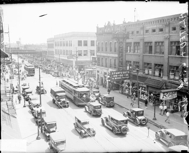
The result was a series of research experiences for which students could sign up, the first of which was an urban history of 55th Street, which runs through Hyde Park and acts as a northern border to the U of C campus. In the mid-20th century, 55th Street was known for a vibrant strip of nightclubs and lounges, including the Bee Hive Lounge near Blackstone Avenue, where Charlie Parker, Thelonius Monk, and Art Blakey all performed, and where Clifford Brown and Max Roach recorded a live album in 1955.
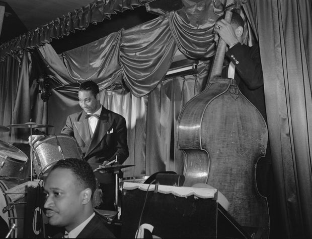
Jazz can still be heard Sunday nights at the Woodlawn Tap, or Jimmy's, at 1172 E. 55th St. But that nightlife scene and nearly all the buildings that housed it was cleared away in the 1950s and 60s, as an urban renewal effort by the city with the cooperation of the university.
"The streetscape was really changed very substantially from being a commercial corridor — kind of one of these little downtown areas — to becoming extremely residential and almost suburban in its character, which is what it is now," Skrable said.
The Chicago Studies program also launched an urban history exploration of 63rd Street in the neighboring Woodlawn community, only a few blocks south of the UChicago campus. For many years, students were warned away from venturing into that area out of concerns about crime.
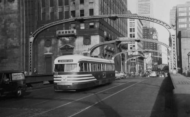
At one time, the branch of the L now known as the Green Line ran over 63rd Street all the way to Stony Island Avenue and Jackson Park, and was a crucial mode of transportation for visitors to the World's Columbian Exposition of 1893. The Woodlawn stretch of 63rd Street was also home to the soaring Tower Theatre movie palace, and a nine-story, 122-foot-tall Illinois Central Railroad office building.
These projects required the analysis of a ream of data that needed to be represented spatially.
"Really, like the best way to help people understand what we learned is to give them a map of 55th as it existed in various decades, and let people click in on a building and understand, pull up data about that building, things that we had learned about it," Skrable said. "The problem was that we needed to create those maps kind of decade by decade of what used to exist."
For that, the Chicago Studies team turned to Sanborn maps. But Sanborn maps aren't widely available beyond paper atlases stored at sites like the Regenstein Library, and digitizing them proved to be a tall order.
That was where student researcher and cartographer Parker Otto came in. Otto took the project in a new direction —using state-of-the-art technology, he digitized the historic maps, and eventually expanded far beyond specific stretches of 55th and 63rd streets.
Initially for the 55th Street and 63rd Street projects, all the digital mapping was done by hand. Researchers had to georeference and draw all the building footprints themselves and then layer on the information, a process that was inefficient to say the least.
Otto joined the effort in June 2023, and by the start of the following academic year, he was leading an effort to make the process easier — writing his own Python code to identify buildings in Sanborn map scans and turn them into high-resolution polygons on a digital map in QGIS, the open-source geographic information system the project uses.
"I stayed up, you know, many nights in a row, pulled all-nighters, you know, really, really worked hard on teaching myself Python," he said.
Otto also worked with a team of students who learned about QGIS and state-of-the-art mapping while also learning about Chicago history.
A painstaking student-run effort
Otto graduated from UChicago in 2024. Afterward, he focused intensely on the Chicago mapping project during a fellowship with the Center for Digital Scholarship at Regenstein Library and then moved to Philadelphia for a graduate program at the University of Pennsylvania.
But Otto remains involved in the Chicago Urban Heritage Project, and has two protégés leading the effort back at UChicago.
Griggs Fuller and Sophia Liu are both sophomores at UChicago, but present their efforts and expertise with the Chicago Urban Heritage Project with the confidence of veteran professors. They were also both part of the project's inaugural research group.
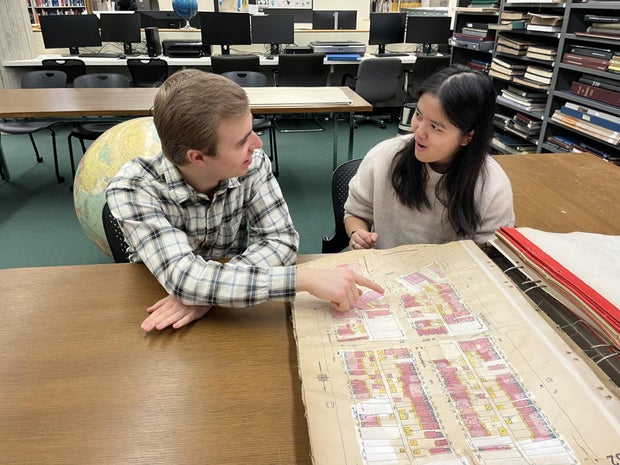
Before moving east, Otto designated Fuller and Liu as the program leaders back on the UChicago campus. The pair now leads the Chicago Urban Heritage Project team on campus, answers questions, and works tirelessly to turn Sanborn maps into user-friendly digital representations.
They don't get academic credit for the project, but they do get paid. And they take their mapping work with them wherever they go.
"I think this job is really unique in the way that it's like, you can essentially do work like, wherever, whenever, like, when I went home for the summer, I was still doing maps, and I was able to just do them whenever, wherever," said Liu. "Like, sometimes my working hours end up being from like, 12 a.m. to 2 a.m. and that's totally fine, as long as, like, the maps are getting in."
Fuller and Liu said they both applied for the positions through the newsletter for Skrable's Chicago Studies program, and it was a perfect fit for their passions.
"We're making it so that you can just go to a website and see, hey, for a given period of time, if we have data for that period of time, what did this area of the city look like at a block-by block-level?" said Fuller. "What building was on this piece of land at this address?"
In the Map Collection Reading Room at Regenstein Library, Fuller and Liu broke down all the data about the past of any given neighborhood, block, or individual plot of land that one can learn from Sanborn maps. Every residence — with pink for brick construction, blue for stone, yellow for wood — appears on the maps, sometimes with stables or coach houses in the back where one would now expect a garage.
The Python machine learning model is trained to read the colors on the Sanborn map and make the footprints so they don't have to be drawn by hand. Fuller and Liu also add notes they learn about the history of a given building — whether it's an ordinary house or two-flat on the city's West Side, or a rubber products manufacturing plant near where McCormick Place now stands.
The result is a clickable map that documents history.
Fascinating discoveries
The team has completed mapping for about 40% of the city for the project. After Otto mapped Hyde Park and Woodlawn, Fuller focused on Kenwood, while Liu focused on the Greater Grand Crossing, Bronzeville, and South Shore areas, and more recently Lawndale. Other researchers branched out to map Logan Square, Washington Park, Englewood, and the Near South Side.
While serious issues such as land use, gentrification, and abandonment come into play with the Chicago Urban Heritage Project, there have been quite a few discoveries that have tickled the researchers' fascination.
While working on digital mapmaking efforts for the Greater Grand Crossing community area, Liu came across the two-flat at 7244 S. Prairie Ave. where Al Capone once lived.
"So that really sent me down like a rabbit hole on like, Al Capone and his history of moving to the house," Liu said.
She came across one website written by a researcher who had somehow made entry into the old Capone house.

"He was showing the different like architectural styles, the molding on the floors and the ceiling. It was really interesting," Liu said. "And there's just so many examples of that, of old churches and religious buildings that used to be there that are now, like, completely different things, like incredible architecture like that. You can see on the maps, like, just from the shape of them, that they're really intricate."
In the massive Sanborn map atlases, updates were also pasted on over the decades, leaving just enough translucence to show the street grid and buildings that stood where expressways were later built.
"Here's, like, two entire city blocks that were in the South Loop that were vibrant and whatnot," Fuller said as he examined a map showing the South Loop near McCormick Place that was developed in the 1920s and updated in the 1950s or 60s. "And now it's just highways, like they just drew highways right over it…. That's the Dan Ryan as it connects to Stevenson."
Skrable and Otto also emphasized other changes documented by the mapping process that dramatically altered the face of Chicago and its neighborhoods, like the removal of streetcar lines that once supported dense, walkable retail districts that are now scarce in large parts of the city.
"You realize that the very dependability of the streetcar, that that really made possible a kind of retail investment in these corridors, because you knew you had traffic flows, and they didn't think about this when they ripped those out, replaced them with buses," Skrable said.
The loss of streetcars, and the prevalence of auto infrastructure and parking lots, decimated once-thriving retail ecosystems, he said.
Otto emphasized one specific retail center that was once bustling beyond all but a few areas of Chicago today.
"Talk about transportation infrastructure being lost and everything being replaced with parking lots, 63rd Street in Englewood — 63rd and Halsted — used to be the largest shopping district between downtown Chicago and downtown St. Louis. It had a flagship Sears, Roebuck & Co. store," he said. "If you look at an old picture from, you know, the 1920s, even post that, actually, to probably about 1950, of 63rd Street and Halsted, it looks like you're in Manhattan."
Go to 63rd and Halsted streets today and you'll find a shopping center anchored by a Save-a-Lot Hometown Grocer with a vast parking lot and the Kennedy-King College campus — a relatively recent development after decades of decline and demolition.
"It's kind of crazy to me to be mapping those areas and seeing just this decline, you know, building after building demolished; huge, monumental department stores demolished and replaced with parking; large swaths of the neighborhood demolished for the Halsted Parkway that kind of envelops around the 63rd and Halsted intersection," Otto said.
Otto emphasized that destination retail and cultural corridors, such as Belmont Avenue and Halsted Street in Lakeview or Milwaukee Avenue in Wicker Park, were once found all around the city.
"And so many of them have been erased, or are in the process of being erased," said Otto. "So what can we learn about these areas, and how can we sort of repair what's been lost?"
Skrable said the data collected for the mapping project is already having an effect on development plans, providing historical information about a given block or neighborhood that otherwise would not be considered.
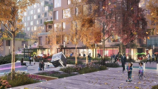
He pointed to the Woodlawn Central plan spearheaded by the Apostolic Church of God, at 63rd Street and Dorchester Avenue. On sites now occupied by parking lots and vacant land, the plan calls for the development of an 8.5-acre mixed-use district with high-density housing, a business incubator, a hotel, a performance venue, and cultural spaces such as festival streets.
"When they brought this proposal to the city, the city pushed back and said: 'Look, we've looked back across the data from the last 20, 30 years, and there's never been this kind of density in this neighborhood. What makes you think this could ever be supported? Why? This is completely out of character with the neighborhood," Skrable said. "We were able to bring data to them that said, well, up until 1970, you know, there was this headquarters for the Illinois Central Railroad that was right here on one of those parking lots. There was a huge hotel right across the street from it. There were a whole series of movie and theater venues that ran down that stretch."
Informed by that historical data, the city changed its position on the Woodlawn development plan, Skrable said.
Interactive maps of several Chicago communities as seen a century ago or more are already available on the Chicago Urban Heritage Project website. Eventually, the goal is to overlay all the data learned from the old maps so that a user can learn about a piece of land in Chicago decade by decade.