Tornado, flood watches issued for parts of Chicago area as severe storms approach Tuesday


Strong storms with the possiblity of tornadoes moves across the Chicago area on Tuesday night.
A Tornado Watch issued for Cook, DuPage, Boone, Lake, Kane, De Kalb, McHenry, Lee, Ogle, and Winnebago counties and Winthrop Harbor to Wilmette Harbor in Illinois has been extended until midnight. In Indiana, a watch is in effect for La Porte until 4 a.m. EDT or 3 a.m. Chicago time.
A Flood Watch was issued for Boone, Central Cook, De Kalb, DuPage, eastern Will, Kane, Kendall, Lake, McHenry, northern Cook, Northern Will, Ogle, southern Cook, southern Will, and Winnebago counties, and Lake County in Indiana until 6 a.m. on Wednesday.
A ground stop was issued at O'Hare Airport due to thunderstorms until 12:45 a.m. on Wednesday.
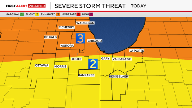
Between 6 p.m. and midnight, the possibility for severe storms to develop is likely, with the area under a two out of five, or enhanced, severe weather risk south of I-80 and a three out of five, or moderate, severe weather risk in the city and north of I-80.
Severe storms are most likely to develop between 6 p.m. and midnight, with their biggest concerns being hail and tornadoes. The greatest threat for large hail is north of I-90.
After around 8:30 p.m., storms are expected to move into areas including McHenry and DeKalb counties. They will be severe upon arrival and pose a tornado threat from the start, along with damaging winds.
All types of severe weather threats are possible in the evening hours into Tuesday night, including damaging winds and flash flooding on top of the tornado and hail threats. Tornado warnings are possible Tuesday night as well.
What to do if there's a tornado warning
If a tornado warning is issued for your area, immediately take shelter int he lowest level of your home or a basement, if possible. If you don't have a basement, or it's not possible to get to one, take shelter in an interior room away from windows like a bathroom, closet or hallway.
If you have time, be sure to bring your pets with you.
If you are outside when a tornado warning is issued, take shelter in a sturdy building immediately. Sheds, storage facilities and mobile homes are not considered safe for tornado warnings by the National Weather Service.
If you're in your car when a tornado warning is issued, you should drive to the closest shelter you can find and take cover immediately. If you can't get to a safe shelter, either get down in your car and cover your head, or abandon your car and seek shelter in a low-lying area like a ditch or ravine.
If you can, bring a flashlight, water and your phone and charger into your safe room with you. If you have a radio, bring that as well to stay informed of weather alerts, changes and when the warning has been cleared.
A tornado warning means a tornado has been sighted or indicated by weather radar, and there is imminent danger to life and property. If a tornado warning is issued for your area, you should take shelter and safety precautions immediately.
ComEd prepares for Tuesday night's storms
ComEd has already sent out crews to stay ahead of any power outages from Tuesday's storms.
"Taking these proactive steps will help us ensure that' were able to respond and take care of whatever damage that this weather causes," said Jeremiah Smith, vice president of distribution operations.
The electric company said they're also bringing in more crews to help restore power quickly. They said they will work through the night as needed.
If you experience a power outage during the storms, you can call ComEd at 800-334-7661 or report it through the app.


