Chicago weather: Strong storms leave damage, power outages across Chicago area


Cleanup is underway after a line of storms raced east through the suburbs and into the city at 70 to 80 miles per hour on Wednesday, and another round of severe storms is heading in Thursday afternoon and evening.
Wind gusts of 72.5 miles per hour were reported at Midway Airport shortly after 4 p.m. on Wednesday.
Storms leave damage, power outages in wake
The line of storms stretched across the entire Chicago area from north to south, moving in a destructive line and leaving damage in their wake.
Citywide, thousands of people called the city's 311 nonemergency service line for help between when the storm began Wednesday afternoon and 6 a.m. Thursday. That includes more than 4,000 people with a tree emergency, nearly 1,500 for other tree debris, and 323 reports of traffic signals out, according to the city's Office of Emergency Management and Communications.
In West Pullman, the winds peeled the roof off a church like the top of a tin can and damaged two other homes on the same block. Trees fell, crushing vehicles and leaving streets impassable.
In Mount Greenwood a massive tree was pulled up from the roots, and crushed three garages. A red pickup parked next to the tree went partially underground and had to be pulled out after the storm.
Stephanie Piniuta lost an elm tree that stood in front of her Beverly hoe for decades, which cracked in half and fell.
"It cracked in half, it split the chimney, and then we thought we were fine," she said.
But they weren't. The limb went through the roof and into the attic.
"We have four to five buckets up there and this afternoon, we're supposedly having someone come with a tarp because we're supposed to get another round of storms," Piniuta said.
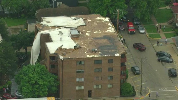
In the Roscoe Village neighborhood in Chicago, a restoration company was busy Thursday not just cleaning up damage from downed trees or power lines, but roofs lifted off buildings.
Inside one home, Michael Guimond and his crew with Romexterra Restoration found the roof had partially lifted.
"They did notice water leaking in the ceiling. That brings us to the fact, okay, upstairs, outside, right? The envelope of your home, your roof," Guimond said. "We're investigating that right now. Our exterior department is behind due to the storm, but … we did respond within 60 minutes yesterday to ensure that the safety of the individuals inside, the occupants are safe."
In response, they'll tarp or shrink-wrap the roof to keep it secured until a more permeant fix can be made. He also offered advice to homeowners to prevent that kind of roof damage.
"The main thing is securing outdoor patio furniture. That can cause a lot of damage, believe it or not. Yearly maintenance to the roof, ensuring that there's no in-creasing shingles, no lifting of the shingles, the caulking on the roof is secured," he said.
Across Chicago and the suburbs, Guimond said his team received 50% more calls than they would on a normal day. They're already preparing for the next set of storms on Thursday afternoon and evening.
"We do have crews on standby for anyone that needs us," he said.
In Orland Park, police said they have multiple reports of downed power lines and trees. Police are asking people to stay away from 108th Ave. and 167th St., 135th St. and Wolf Road, 145th St. and Brentwood, and the 9200 block of 145th Street, because of downed power lines, and from 104th Ave. and 167th St. for a tree down in the roadway.
In Oak Lawn, it was reported that lightning struck a home. It was said that two trees in the backyard of the home fell and landed on the porch and damaged the home.
In Minooka and Evergreen Park, large downed trees were reported. In Plainfield, a downed tree was reportedly blocking Schlapp Road about half a mile south of IL-126.
In Antioch, there were reports of siding ripped off of buildings and small tree limbs downed by the winds.
CBS Skywatch was in Stickney, where strong winds tore parts of a roof off a building, leaving what appeared to be a large white tarp hanging from it with debris in the street, as cars tried to avoid it.
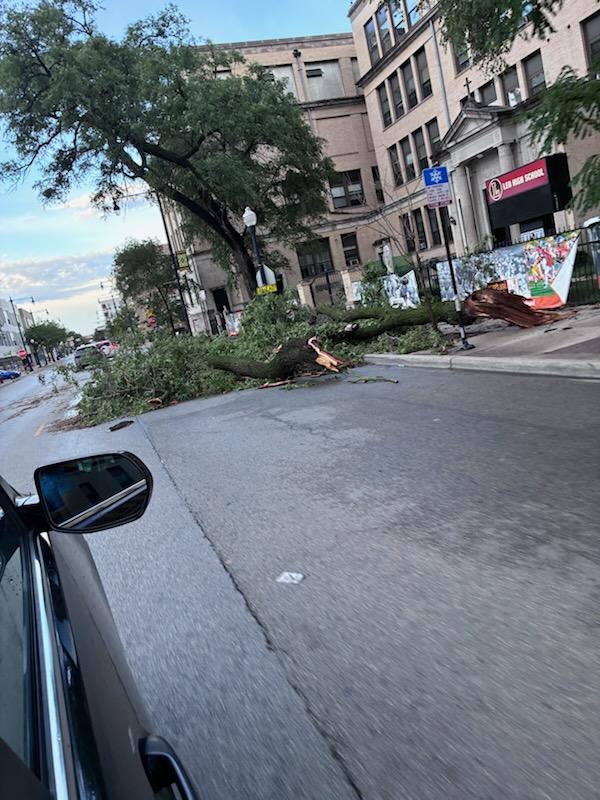
Trees were also downed by Leo High School on the city's South Side.
In the Park Manor neighborhood, a winery had its roof blown off and lost power.
In the West Pullman neighborhood, several large fallen trees were blocking streets.
In Mount Greenwood, a large tree fell and crushed three garages.
In southwest suburban Shorewood, a large tree came down on a woman's home on Wednesday. Neighbors said a woman in her 60s lives there, and she came out covered in debris from her ceiling that came down. Thankfully, she's okay.
Neighbors said they heard big loud booms during the storm on Wednesday, and ran to their basement, then came out to lots of debris, many of them worried about the woman inside the home the tree fell on.
"It was horrific, and then I was just worried about Janet, my neighbor of almost 30 years, and I went running over there, and she was actually opening the door as I came up, and she had debris in her home that landed at her TV room right there. Luckily, she was in the living room, and then the second branch came through the living room and just barely missed her. She was pretty shook up," Jim Peart said.
People in Shorewood said the ground has become so saturated from all the rain this week that a lot of older trees were uprooted in Wednesday's storm.
One woman said she has about $3,000 worth of cleanup ahead of her after two massive trees, both about 150 years old, came down in her yard.
People in Shorewood said they are not expecting power to come back on until Saturday, maybe even Sunday, given all the damage.
Some people might not get power back until Saturday
ComEd chief operating officer David Perez said 450,000 customers were impacted by Wednesday's storms.
Perez said, as of 11 a.m. Thursday, 68 percent customers who lost power had their service restored. They're expecting 80 percent of the outages to be restored by 11 p.m. but Thursday night's additional storms could cause even more damage.
Perez said the other 20 percent are the most impacted areas, and it could possibly take longer to get their power restored, because ComEd has to rebuild from the ground up.
"Our most impacted areas were from Crestwood to Chicago and from Alsip to Joliet," he said. "I was walking the most impacted neighborhoods in this area and that's what you're seeing; the trees that came down on top of our infrastructure completely took down the poles, the wires, the equipment."
ComEd said they had 2,000 crews on the ground on Wednesday, and added another 1,000 on Thursday, many from outside Illinois.
Darlene Prestia said she got a notification from ComEd that the power at her home in Palos Heights wouldn't be restored until Saturday.
"I think we're in for a few days of hot weather," she said. "We do have family in the area, but their power is out also, so we're all kind of just all winging it out together."
Eileen Leonard lives right next door to Prestia and said she got in her house in the nick of time as the storms hit on Wednesday.
"I no more got in and closed the door, and I mean, wham. I mean, it hit out of nowhere, just totally like a block of bricks hit you," she said.
Palos Heights officials said they've opened a cooling center at the Palos Heights Recreation Center at 6601 W. 127th St. It is open until 9 p.m. on Thursday and does have power.
As of 3:30 p.m. Thursday, ComEd said they had more than 4,600 active power outages affecting more than 130,000 customers throughout the Chicago area, mostly in Cook and Will counties.
CTA said they are working to restore service on the Midway-bound Orange Line as the weather has left trains standing in both directions. Meanwhile, Metra is advising riders to expect extensive delays system-wide due to debris and downed wires on multiple tracks.
More storms, with higher tornado risk, forecast on Thursday
Wednesday's storm chances continue until about midnight, but an even greater risk for severe weather and especially tornadoes follows on Thursday.
Again, two rounds of storms are expected. The first will be mainly in the northern part of the Chicago area between 11 a.m. and 3 p.m. Then, between 3 p.m. and 9 p.m., another round of storms moves in, with tornadoes being the main threat.
Thursday will again be very hot, with highs in the upper 80s that, with the heat index, will feel like the mid-90s.
A Tornado Watch is in effect for the entire Chicago area, including Boone, Cook, DuPage, Grundy, Kane, McHenry, De Kalb, Kankakee, Lake, La Salle, Kendall, Livingston, Lee, Ogle, Will and Winnebago counties in Illinois and Benton, Jasper, Newton, Lake and Porter counties in Indiana until 9 p.m.
A Flood Watch is in effect for Eastern Will, Ford, Grundy, Iroquois, Kankakee, La Salle, Livingston, southern Will in Illinois, and Benton, Jasper, Lake, Newton, and Porter in Indiana until 4 a.m. Thursday.


