How much snow will Massachusetts get?
BOSTON - As expected, the snow moved in early Tuesday and the highest impacts will be felt over southeastern Massachusetts.
There is a Winter Storm Warning for areas south of the Massachusetts Turnpike (where there is the greatest chance of 6 inches or more of snow) and a Winter Weather Advisory north of the Pike.
Watch: Interactive Radar
When will the snow fall in Massachusetts?
The snow will come down very heavily until 3 p.m. with rates of 1-to-3 inches per hour at times over southeastern Massachusetts.
The snow will already begin to head east and out to sea by the afternoon. The snow will taper off in western and central Mass. between 1 and 2 p.m.
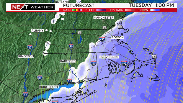
Between 3 and 5 p.m., the snow will be quickly coming to an end with the final flakes falling over the outer Cape around 5 p.m.
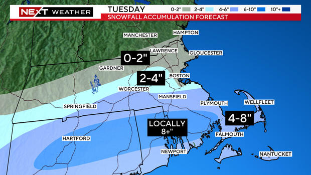
How much snow in Massachusetts?
4-to-8 inches Southern Worcester County, southern Norfolk County and all of Plymouth and Bristol counties. Also, Cape Cod and the Islands. Locally, amounts above 8 inches are possible in southern Bristol and Plymouth counties.
2-4" Just north of Worcester and down the Pike to Route 95.
0-2" Immediate coastline from Boston north through the North Shore and all of Essex County. Also all of northern Middlesex and Worcester counties.
Wind warning
The highest winds with this storm will be over Cape Cod and the Islands. There is a high wind warning posted there for gusts as high as 55 mph through Tuesday afternoon.
Along the rest of the coastline, gusts could reach as high as 20-to-40 mph.
Coastal flooding
We expect minor to moderate coastal flooding between noon and 5 p.m. at all east, northeast and north facing beaches of Massachusetts.
High astronomical tides combined with strong, onshore winds will push 1-to-2 feet of water onto vulnerable shore roads.
What's next?
After the storm departs, temperatures will plunge and any untreated surfaces will become slippery Tuesday night.
Valentine's Day will be cold and windy Wednesday. Wind chills will be in the teens and 20's all day long.

The next snow
We then have two more chances of snow. A quick band of snow is likely later on Thursday with a few inches accumulation on average.
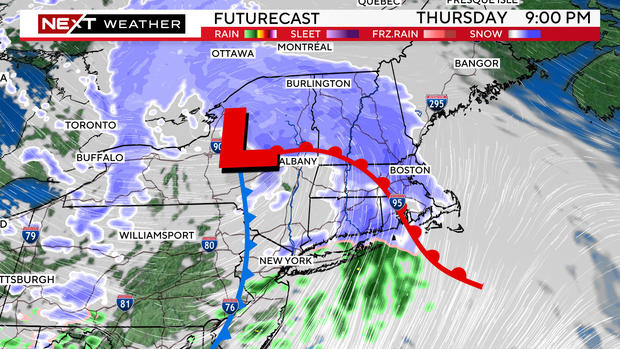
Then, we have to watch a storm which will be diving to our south on Saturday. This MAY end up too far south to have any impacts here in New England but, at this time, we cannot rule out some additional snowfall.


