Thanksgiving Travel Forecast: Lots Of Rain, Some Snow
BOSTON (CBS) – The biggest storm we have seen in months is on our doorstep, just in time to make Thanksgiving travel a bit messy. And, it isn't just creating travel headaches here in New England, it is carving a path thousands of miles long from the Desert Southwest to the Gulf Coast States and now up the entire East Coast.
Check: Traffic | Current Conditions | Interactive Radar | WBZ Weather Blog
If your holiday travel is taking you anywhere from Atlanta to Charlotte or perhaps to Washington D.C., Philly or New York City…be prepared for delays through the air and on the roads.
Thankfully, nearly all of the precipitation is falling in the form of rain. The snow accumulation will be confined to the extreme western edge of the storm in cities like Cleveland, Pittsburgh and Buffalo where several inches will likely accumulate in the next 24 hours.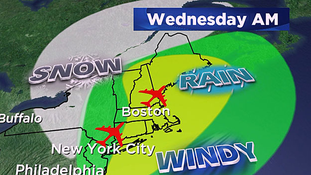
So, what to expect here in New England…A whole lot of rain and wind…
TIMELINE:
The opening moments of this storm will arrive around the evening commute tonight and may actually fall as a bit of a mix of rain and snow, especially in Central and Western Massachusetts. Any mix will quickly change to all rain and become steady and heavy between 8-10pm tonight. It will rain all night long, heavy at times and continue right through the Wednesday morning commute. Rain will taper to showers by Wednesday afternoon and shut off completely Wednesday evening. There may be one final burst of precipitation later Wednesday night or early Thursday morning as the colder air rushes in…This would likely fall as mainly snow and could coat the ground in spots for Thanksgiving morning.
RAIN AMOUNTS:
Rain will fall very heavily at times, up to a half inch per hour. Therefore we are forecasting an average of 1-3" of total rainfall across Southern New England, with a few locally higher amounts not out of the question.
River flooding is not a concern given the lack of rainfall we have had over the past several months. Street flooding is almost a certainty especially where storm drains may be clogged with fallen leaves.
WINDS:
There will be very strong winds just above the ground during this storm…in fact hurricane force winds will likely be just a few hundred feet above the surface. Thankfully we are not expecting these winds to completely "mix down" to the ground, but wind gusts between 25-50mph are likely, especially in elevated areas and along the South Coast. Therefore some downed tree limbs and power outages are possible. Winds should peak midday on Wednesday and taper Wednesday evening. Coastal flooding is not a concern given the low astronomical tides on Wednesday, but there is potential for some minor splashover on the South Coast.
So there you have it…again the good news is by the time the high school football games kickoff Thursday morning and you sit down for Turkey Dinner, this will all be long gone…you will be free to sit back and enjoy the feast without Mother Nature interfering!
Happy Thanksgiving!
Follow Terry on Twitter @TerryWBZ
MORE LOCAL NEWS FROM CBS BOSTON


