Worst flooding since Tropical Storm Irene possible in parts of New England
By Terry Eliasen, WBZ-TV Meteorologist, Executive Weather Producer
BOSTON - There is life-threatening flooding occurring in parts of western Massachusetts, southwestern New Hampshire and Vermont. WBZ-TV has issued a NEXT Weather Alert for localized flooding from heavy downpours expected to impact central and eastern Mass. throughout the day Monday.
In the last 24 hours, parts of western New England have received upwards of 4-to-8 inches of rain, the equivalent of two months worth of water. The bullseye has been largely over portions of Vermont and southwestern New Hampshire. Within this area, there have been numerous washed out roads and flooding-related rescues. Some experts are comparing this event to the historic flooding that occurred back in 2011 with Tropical Storm Irene.
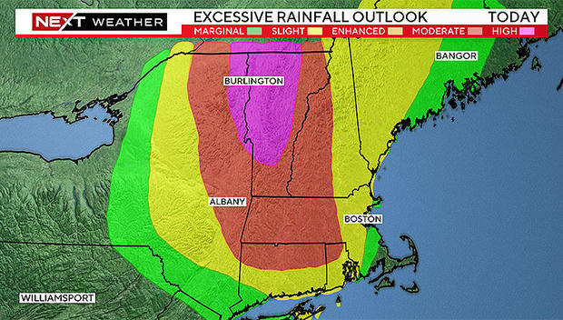
You can see the National Weather Service has highlighted much of central and northern Vermont in the "high risk" category for excessive rainfall. That's a highly rare occurrence for this area.
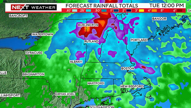
Looking at the rainfall forecast for the next 24 hours, you can see an additional 2-to-4 inches-plus is expected in parts of Vermont with lower amounts to the east.
While the rain and flooding won't be nearly as impactful in eastern Mass. as it has been in parts of western and northern New England, there will be some local impacts on Monday. The risk of severe thunderstorms is fairly low, the main threat to monitor will be localized flooding from a very slow-moving cluster of downpours.
The storms will largely be exiting the coast Monday evening and we will quiet down and dry out overnight.
Tuesday will be a much nicer day with increasing sunshine, highs in the 80s and humidity a tad lower. More importantly, the rain chances will drop to just about zero-percent after the early morning hours.
Wednesday will be a scorcher with highs back in the low 90s, albeit with reasonable humidity levels.
Later this week, that all-too-familiar pattern returns - high humidity along with a daily threat for pop-up showers and thunderstorms. And that storm threat looks to linger into the upcoming weekend as well.


