Map shows where snow will be the heaviest in Massachusetts early Wednesday morning
BOSTON - Snow is returning to Massachusetts Tuesday night into Wednesday morning.
This will not be a highly impactful storm. Just about all of it will come overnight and snowfall accumulations will be on the lighter side. However, if you are traveling early on Wednesday, you may need to leave a little extra time.
When will it snow?
The snow arrives from west to east late Tuesday night. The first flakes will fall between 9 and 10 p.m. in western Massachusetts, between 10 and 11 p.m. in central Massachusetts and 11 p.m. to midnight in eastern Massachusetts and Boston.
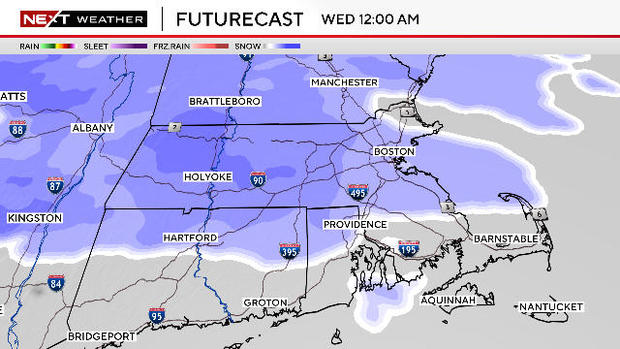
This will be a very quick moving storm. The final flakes will be exiting the coastline between 4 and 5 a.m. Wednesday, so the total duration is only about 4-to-6 hours.
The worst travel times will be between midnight and about 6 a.m. Thereafter, road conditions will steadily improve.
How much snow?
Total snow accumulation will average from a coating to two inches for a good portion of southern New England including Boston and Worcester.
South of the Massachusetts Turnpike, expect the lower end of that range and south of Providence and Plymouth, we don't expect any accumulation at all.
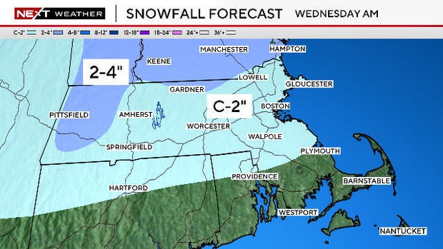
The highest snowfall amounts will be in the Berkshires, northernmost Worcester County and throughout Vermont and New Hampshire. We are forecasting 2-to-4 inches in those areas.
Snow squalls possible
For the rest of the morning on Wednesday, conditions will be quiet and partly sunny.
As a cold front passes through later in the afternoon, there will likely be one final round of rain and snow showers.
If you plan to be on the roads between 2 and 4 p.m., you should be alert to the possibility of a few briefly intense snow squalls.
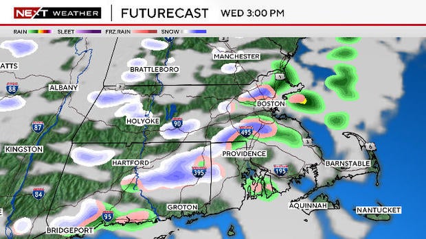
These could drop an inch of snow in a very short period of time, causing roads to become hazardous in a hurry.
Shot of cold
Behind that cold front, there will be another blast of very cold air. Stepping outside early Thursday morning, it will feel like near zero degrees.
High temperatures on Thursday will remain largely below freezing for a good portion of our area.
We will get a quick shot of cold Wednesday night through Thursday. Morning lows will drop into the single digits in many of the suburbs and daytime highs will be stuck in the 20s Thursday.
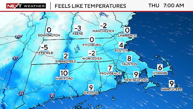
Busy northwest winds will make it feel like the single digits and teens for most of our area.
Friday storm
We will have more Wednesday on a potential follow up storm on Friday. For now, that storm looks more likely to be a rain or rain/mix event.
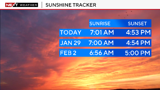
Let me leave you with some positive vibes!
Sunrises are getting earlier and earlier. After Wednesday, they will begin before 7 a.m.!
Also, starting this Sunday, our sunsets will cross the 5 p.m. mark! We are now gaining more than two minutes of daylight each day.
Catch us on CBS News Boston, WBZ-TV, and WBZ.com for the latest forecasts and snow updates.


