Snow could be part of long mid-week storm coming to Massachusetts
A storm headed for the Boston area this week will bring rain, wind and possibly heavy snow to parts of Massachusetts. Here's the latest forecast from the WBZ NEXT Weather Team.
BOSTON - This is no joke. The calendar may say April 1st but I assure you this is NOT an April Fools' prank. I wish it were.
New month, same old story. Another wet, cloudy and stormy week is on the way. This will be a long-duration storm with impacts stretching from Tuesday through Friday. We will see heavy rain, strong winds, renewed flooding and even some accumulating snow at times this week in southern New England.
What should we expect?
Monday: A quiet start to the week. Most of the area remains dry. Lots of clouds around, but we should see some splashes of sunshine here and there. This may be our last glimpse of sunshine until next weekend!
Tuesday: Clouds thicken up. Rain slowly nudges into the area from southwest to northeast. Not expecting any heavy rain. The steadiest rain will be over Connecticut and Rhode Island with just spotty showers and drizzle over most of central and eastern Massachusetts. Light rain continues Tuesday night with the chance of some wet flakes mixing in over portions of Worcester County and the Berkshires. No accumulation expected.
Wednesday and Thursday: This is when we get the main impacts from the storm. During the day Wednesday, it is more of the same. Mainly light to moderate rain showers. The intensity picks up Wednesday afternoon and evening. The "brunt" of the storm and main impacts are roughly between 7 p.m. Wednesday and 7 a.m. Thursday.
During this time, we anticipate periods of heavy rain, strong east-northeast winds and, believe it or not, some mixing with sleet and snow in parts of the area.
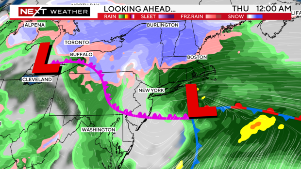
Potential for heavy rain
There is the potential for another round of street, river and basement flooding with this system. Current forecasts are for 1 to 3 inches of water.
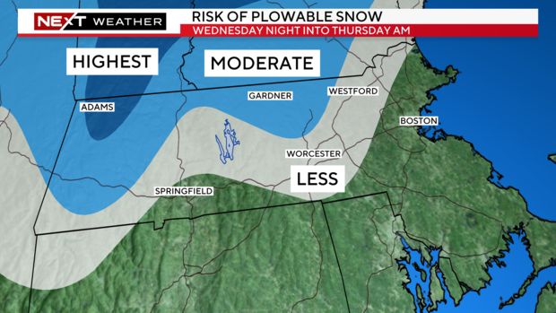
How much snow?
This remains a bit of a wildcard. It is likely that some wet snow will mix in Wednesday night but there are questions as to how far east this will happen and how much will be able to accumulate given the relatively mild temperatures at ground level.
The best chance of any significant snowfall accumulation will be in elevated areas. This is very common with early and late season storms.
The Berkshires and hills of northern Worcester County (mainly areas above 800 feet or so) have the highest risk of a plowable event. Even in these areas, temperatures will hover near or slightly above 32 degrees for most of Wednesday night. Any snow that does accumulate will be very heavy and wet and could lead to power outages given the weight of the snow on wires and limbs.
Over the rest of central and eastern Massachusetts, snow accumulation will be much more difficult, but not impossible.
Areas north and west of 495 could see some mixing and sloppy, light accumulation. Inside 495 and closer to the coast, the odds are stacked against any significant snowfall. Any snow that does mix in would likely melt on contact.
We should have a better read on snowfall chances by Monday night.
Power outages possible
The strongest winds will be located along the immediate coastline and in particular, over Cape Cod and the Islands. We could see east-northeast gusts topping 40 or even 50 mph Wednesday night into early Thursday in these areas. This is highly dependent on the track of the storm, and we will have a better assessment in the next 24-48 hours.
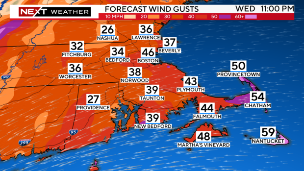
There is a risk of some outages in the areas where the heavy, wet snow accumulates. Again, the highest risk being in the highest elevations of central and western Massachusetts.
Coastal flooding
Tides are astronomically low this week so the risk for significant coastal flooding is also low. The Thursday morning high tide (between 7 and 8 a.m.) would be the one to watch for some minor flooding issues.
Slow recovery
The storm will be very slow to depart later this week. It is likely that clouds and showers will linger Thursday PM and most of Friday.
We may stay under a cyclonic flow through part of the upcoming weekend as well. This could mean more pop up showers Saturday and periods of clouds both weekend days.
Don't forget the solar eclipse is next Monday, April 8! The forecast looks dry, but the main question is whether we may still have some linger patchy clouds. More to come on this!


