It's Going To Feel A Lot Like Winter
BOSTON (CBS) - Let's face it, our weather has been downright boring lately.
Check: Current Conditions
I am sure there aren't many of you that are complaining, but I wonder if we have grown so used to our quiet, pleasant weather that we could be caught off guard?
What if, say, a blast of Arctic cold air were to arrive along with some briefly heavy snow squalls just before and during the morning commute Tuesday?
I think there would be more than a few folks who would be digging through their drawers looking for the winter gloves and hats and trying to remember what gear to put their car in to best traverse the snow.
Well, get ready, we may just be in for our first real taste of winter, more like an appetizer.
At this moment, some of the coldest air we have seen since last winter is building to our North, in portions of Canada. It is amassing behind an Arctic cold front which is now making its way through the Upper Midwest, headed straight for New England Monday night.
We may see our first few sprinkles, likely rain, just before midnight.
But the real interesting thing about this cold front is that much of the precipitation will be what we call "anafrontal," meaning much of the rain-snow will be falling after the cold air arrives, lending to a greater chance of what's falling to be white, instead of wet.
In the end, it will come down to intensity. If the precipitation is coming down heavy enough it should drag down enough cold air with it (from aloft in the atmosphere) to change what would be some briefly heavy rain showers into snow squalls. And, this could happen all the way down to our South Coast, right during the morning commute on Tuesday.
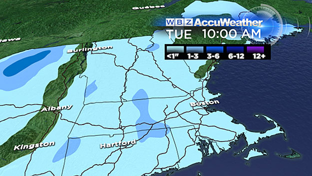
While amounts would be light (generally an inch or less), if it comes down hard enough and in combination with some very cold Arctic air, it may actually stick to some pavement for a brief time.
So what does this all mean?
For a short period of time, in some locations Tuesday morning, it may feel and look a lot like winter around here! So, just in case, you may want to leave a little extra time for your commute Tuesday morning and dig those boots out of the cellar.
Regardless of rain versus snow, what is certain is the cold air is headed our way.
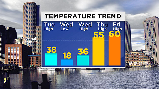
This will be our coldest air mass of the season thus far. Temperatures on Tuesday will not reach much higher than the upper 30's and actually will be dropping during the afternoon.
The core of the cold will be from Tuesday night through Wednesday night. Daytime highs will be in the 30's with wind chills in the 20's and at night, may of the suburbs will be in the teens. Expect low 20's in Boston.
The good news is that just like the snow squalls, this cold blast will not last long.
We will have a very quick recovery later this week.
High temperatures on Thursday and Friday will reach well into the 50's, perhaps touching 60 degrees! And no major storms or cold seem likely for the short term, foreseeable future.
You can follow Terry on Twitter at @TerryWBZ.
MORE LOCAL NEWS FROM CBS BOSTON


